IMAGES TAKEN NEAR TO
Grosmont, ABERGAVENNY, NP7 8LG
Introduction
This page details the photographs taken nearby to NP7 8LG by members of the Geograph project.
The Geograph project started in 2005 with the aim of publishing, organising and preserving representative images for every square kilometre of Great Britain, Ireland and the Isle of Man.

There are currently over 7.5m images from over14,400 individuals and you can help contribute to the project by visiting https://www.geograph.org.uk
Image Map
Images are licensed for reuse under creativecommons.org/licenses/by-sa/2.0
Notes
- Clicking on the map will re-center to the selected point.
- The higher the marker number, the further away the image location is from the centre of the postcode.
Image Listing (7 Images Found)
Images are licensed for reuse under creativecommons.org/licenses/by-sa/2.0
Image
Details
Distance
1
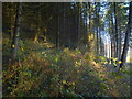
Edge of Sky Covert
Coniferous woodland on the Monnow valley side.
Image: © Jonathan Billinger
Taken: 29 Nov 2016
0.12 miles
2
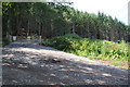
Sky Covert
Gate and entrance to the forestry lane of Sky Covert.
Image: © Philip Halling
Taken: 3 Aug 2013
0.14 miles
3
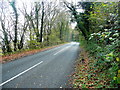
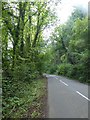
B4347 towards Monmouth
The short section of B road which clips the north-east corner of the gridsquare.
Image: © Jonathan Billinger
Taken: 17 Nov 2011
0.16 miles
4
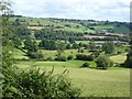
The Monnow valley seen from Dyffryn Cottages
Lower Dyffryn Farm can be seen in the middle distance, with Great Demesne Farm Image on the far side of the valley.
Image: © Oliver Dixon
Taken: 5 Sep 2020
0.16 miles
6
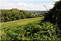
Farmland on the Monnow Valley
Farmland on the Monnow Valley with Box Farm in the middle distance.
Image: © Philip Halling
Taken: 3 Aug 2013
0.18 miles
7
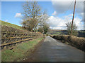
No white lines
The B4347 heading North to Grosmont becomes very narrow in places.
Image: © Pauline E
Taken: 4 Mar 2009
0.22 miles