IMAGES TAKEN NEAR TO
Grosmont, ABERGAVENNY, NP7 8LE
Introduction
This page details the photographs taken nearby to NP7 8LE by members of the Geograph project.
The Geograph project started in 2005 with the aim of publishing, organising and preserving representative images for every square kilometre of Great Britain, Ireland and the Isle of Man.

There are currently over 7.5m images from over14,400 individuals and you can help contribute to the project by visiting https://www.geograph.org.uk
Image Map
Images are licensed for reuse under creativecommons.org/licenses/by-sa/2.0
Notes
- Clicking on the map will re-center to the selected point.
- The higher the marker number, the further away the image location is from the centre of the postcode.
Image Listing (5 Images Found)
Images are licensed for reuse under creativecommons.org/licenses/by-sa/2.0
Image
Details
Distance
1
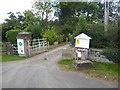
Gateway to Part-y-Seal
Entrance to gardens, tearoom and B and B in the Monnow valley.
Image: © Oliver Dixon
Taken: 5 Sep 2020
0.09 miles
3
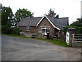
Entrance to Part-y-seal Farm
With a view over the Monnow Valley to Garway Hill.
Image: © Pauline E
Taken: 4 Mar 2009
0.10 miles
4
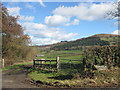
View towards Part-y-seal
The River Monnow winds its way down the valley. Most of this grid square is in Wales but the northeast corner is in England.
Image: © Pauline E
Taken: 4 Mar 2009
0.11 miles
5
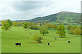
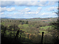
Beef pasture in the Monnow valley
The rich pasture of Part y Seal viewed from the B4347. The bald top of Garway Hill over the border in Herefordshire dominates the background.
Image: © Jonathan Billinger
Taken: 14 May 2010
0.21 miles