IMAGES TAKEN NEAR TO
Grosmont, ABERGAVENNY, NP7 8LD
Introduction
This page details the photographs taken nearby to NP7 8LD by members of the Geograph project.
The Geograph project started in 2005 with the aim of publishing, organising and preserving representative images for every square kilometre of Great Britain, Ireland and the Isle of Man.

There are currently over 7.5m images from over14,400 individuals and you can help contribute to the project by visiting https://www.geograph.org.uk
Image Map
Images are licensed for reuse under creativecommons.org/licenses/by-sa/2.0
Notes
- Clicking on the map will re-center to the selected point.
- The higher the marker number, the further away the image location is from the centre of the postcode.
Image Listing (2 Images Found)
Images are licensed for reuse under creativecommons.org/licenses/by-sa/2.0
Image
Details
Distance
1
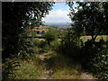
View east from track on Graig Syfyrddin
In the distance, May Hill in Gloucestershire on the northern edge of the Forest of Dean is just visible.
Image: © Philip Halling
Taken: 30 Jul 2006
0.07 miles
2
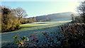
Frosty slope
The morning sun is beginning to touch the frozen slope below Craig Syfyrddin.
Image: © Jonathan Billinger
Taken: 29 Nov 2016
0.11 miles