IMAGES TAKEN NEAR TO
Pandy, ABERGAVENNY, NP7 8HH
Introduction
This page details the photographs taken nearby to NP7 8HH by members of the Geograph project.
The Geograph project started in 2005 with the aim of publishing, organising and preserving representative images for every square kilometre of Great Britain, Ireland and the Isle of Man.

There are currently over 7.5m images from over14,400 individuals and you can help contribute to the project by visiting https://www.geograph.org.uk
Image Map
Images are licensed for reuse under creativecommons.org/licenses/by-sa/2.0
Notes
- Clicking on the map will re-center to the selected point.
- The higher the marker number, the further away the image location is from the centre of the postcode.
Image Listing (3 Images Found)
Images are licensed for reuse under creativecommons.org/licenses/by-sa/2.0
Image
Details
Distance
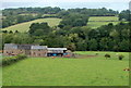
2
The Monnow valley at Great Goytre
The Black Mountains beyond to the left.
Image: © Jonathan Billinger
Taken: 21 Jan 2012
0.24 miles
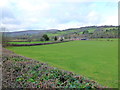
3
The Monnow valley
Looking north from the A465 over the border from Monmouthshire towards the sunlit slopes of Herefordshire.
Image: © Jonathan Billinger
Taken: 21 Jan 2012
0.24 miles