IMAGES TAKEN NEAR TO
Llanvihangel Crucorney, ABERGAVENNY, NP7 8EW
Introduction
This page details the photographs taken nearby to NP7 8EW by members of the Geograph project.
The Geograph project started in 2005 with the aim of publishing, organising and preserving representative images for every square kilometre of Great Britain, Ireland and the Isle of Man.

There are currently over 7.5m images from over14,400 individuals and you can help contribute to the project by visiting https://www.geograph.org.uk
Image Map
Images are licensed for reuse under creativecommons.org/licenses/by-sa/2.0
Notes
- Clicking on the map will re-center to the selected point.
- The higher the marker number, the further away the image location is from the centre of the postcode.
Image Listing (13 Images Found)
Images are licensed for reuse under creativecommons.org/licenses/by-sa/2.0
Image
Details
Distance
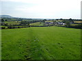
1
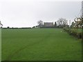
Approaching Llanerch
This shows the Offa's Dyke National Trail climbing through a field to this building ahead marked as Llanerch on the map.
Image: © Chris Heaton
Taken: 9 May 2006
0.08 miles
2
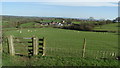
Gate in the hedge
This small gate was sited in the hedge in the farm track here. It provides a decent view of the Big Skirrid, Ysgyryd Fawr at Abergavenny.
Image: © Jeremy Bolwell
Taken: 6 Sep 2010
0.10 miles
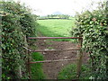
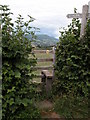
3
Lilies by the gate
The gate is used by Offa's Dyke Path as it passes Llanerch.
Image: © John Allan
Taken: 17 Jun 2019
0.13 miles
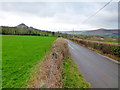
4
Lane junction, with The Skirrid in the background
Image: © Rob Purvis
Taken: 26 Aug 2015
0.16 miles
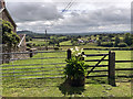
5
Offa's Dyke Path descending a field in Monmouthshire
From the path a large Monmouthshire farmhouse can be seen, Great Park.
Image: © Jeremy Bolwell
Taken: 6 Sep 2010
0.18 miles
6
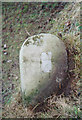
Old Milestone at Llanerch, south of junction with Hill Street
By the UC road, in parish of Crucorney (Monmouthshire District), Llanerch, 25m from junction with Hill Street and Offa's Dyke fingerpost.
Inscription once read:-
: (HEREFORD 18) : : (ABER)GAV(ENNY) / 6 :
Surveyed
Milestone Society National ID: MON_AGOHF06.
Image: © Milestone Society
Taken: Unknown
0.18 miles
7
Minor road and twin peaks
The Monmouthshire countryside to the north of Ysgyryd Fawr, left, and Y Fal (Sugarloaf) half-hidden right.
Image: © Jonathan Billinger
Taken: 21 Jan 2012
0.19 miles
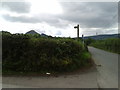
8
Stile on Offa's Dyke LDP
In the background are the Black Mountains.
Image: © Philip Halling
Taken: 6 Aug 2006
0.20 miles
9
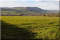
View to the Black Mountains
View to the Black Mountains with the Hatterral Ridge in the centre.
Image: © Philip Halling
Taken: 15 Mar 2014
0.22 miles
10
On Offa's Dyke Path - view to Great Park from near Llanerch
Image: © Colin Park
Taken: 18 Apr 2018
0.22 miles