IMAGES TAKEN NEAR TO
Llanvihangel Crucorney, ABERGAVENNY, NP7 8EF
Introduction
This page details the photographs taken nearby to NP7 8EF by members of the Geograph project.
The Geograph project started in 2005 with the aim of publishing, organising and preserving representative images for every square kilometre of Great Britain, Ireland and the Isle of Man.

There are currently over 7.5m images from over14,400 individuals and you can help contribute to the project by visiting https://www.geograph.org.uk
Image Map
Images are licensed for reuse under creativecommons.org/licenses/by-sa/2.0
Notes
- Clicking on the map will re-center to the selected point.
- The higher the marker number, the further away the image location is from the centre of the postcode.
Image Listing (4 Images Found)
Images are licensed for reuse under creativecommons.org/licenses/by-sa/2.0
Image
Details
Distance
1
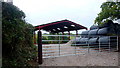
New farming facilities
The structure does not yet (2015) feature on mapping.
Image: © Jonathan Billinger
Taken: 17 Oct 2015
0.13 miles
2
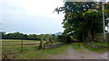
Track and footpath
The track has featured in the last geograph taken here almost exactly five years earlier in October 2010 Image
As is disappointingly common in this corner of Wales, there is no sign of public footpath signage.
Ysgyryd Fawr can be seen beyond.
Image: © Jonathan Billinger
Taken: 17 Oct 2015
0.15 miles
4
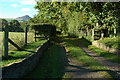
Track entrance and Ysgyryd Fawr
Track entrance and view of Ysgyryd Fawr viewed from a country road to the north of Llangattock Lingoed.
Image: © Philip Halling
Taken: 16 Oct 2010
0.18 miles