IMAGES TAKEN NEAR TO
Penbidwal Lane, ABERGAVENNY, NP7 8ED
Introduction
This page details the photographs taken nearby to Penbidwal Lane, NP7 8ED by members of the Geograph project.
The Geograph project started in 2005 with the aim of publishing, organising and preserving representative images for every square kilometre of Great Britain, Ireland and the Isle of Man.

There are currently over 7.5m images from over14,400 individuals and you can help contribute to the project by visiting https://www.geograph.org.uk
Image Map
Images are licensed for reuse under creativecommons.org/licenses/by-sa/2.0
Notes
- Clicking on the map will re-center to the selected point.
- The higher the marker number, the further away the image location is from the centre of the postcode.
Image Listing (4 Images Found)
Images are licensed for reuse under creativecommons.org/licenses/by-sa/2.0
Image
Details
Distance
1
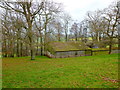
Green-roofed barn
So green is this building at Wood Farm that it melts into the winter woodland.
Image: © Jonathan Billinger
Taken: 21 Jan 2012
0.02 miles
2
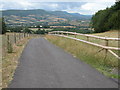
Driveway to Wern-gounsel
This is a long driveway to a farm which situated in the next grid square. In the background is a fine view of the west Herefordshire countryside in the shadow of the eastern escarpment of the Black Mountains.
Image: © Philip Halling
Taken: 6 Aug 2006
0.05 miles
3
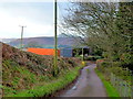
Lane to Pandy
The orange trailer belongs to Walnut Farm.
Sugarloaf, Y Fal, can be seen in the distance.
Image: © Jonathan Billinger
Taken: 21 Jan 2012
0.09 miles
4
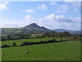
Sheep pasture, Great Campston
Rural Monmouthshire, looking towards the distinctive outline of Ysgyryd Fawr.
Image: © Gordon Hatton
Taken: 18 Oct 2011
0.20 miles