IMAGES TAKEN NEAR TO
Llanvihangel Crucorney, ABERGAVENNY, NP7 8DH
Introduction
This page details the photographs taken nearby to NP7 8DH by members of the Geograph project.
The Geograph project started in 2005 with the aim of publishing, organising and preserving representative images for every square kilometre of Great Britain, Ireland and the Isle of Man.

There are currently over 7.5m images from over14,400 individuals and you can help contribute to the project by visiting https://www.geograph.org.uk
Image Map
Images are licensed for reuse under creativecommons.org/licenses/by-sa/2.0
Notes
- Clicking on the map will re-center to the selected point.
- The higher the marker number, the further away the image location is from the centre of the postcode.
Image Listing (89 Images Found)
Images are licensed for reuse under creativecommons.org/licenses/by-sa/2.0
Image
Details
Distance
1
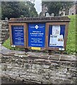
Parish of Crucorney Fawr noticeboards, Monmouthshire
Near steps leading up to St Michael's churchyard in Llanvihangel Crucorney.
In September 2024 the board on the left shows
WEEKLY PARISH SUNDAY SERVICES
Holy Eucharist
8.30am at St David's Church Llanthony
(1st Sunday of the month autumn / winter)
9.30am at St Martin's Church Cwmyoy
11am here at St Michael's Church.
Image: © Jaggery
Taken: 22 Sep 2024
0.03 miles
3

Vehicle display area, Llanvihangel Crucorney
In the SW corner of the SMG (Skirrid Mountain Garage) site. http://www.geograph.org.uk/photo/3846102
Image: © Jaggery
Taken: 19 Feb 2012
0.04 miles
4
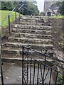
Churchyard entrance steps, Llanvihangel Crucorney, Monmouthshire
Steps ascend to St Michael's churchyard in the Church in Wales Diocese of Monmouth.
Image: © Jaggery
Taken: 22 Sep 2024
0.04 miles
5
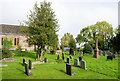
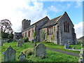
Graveyard at St. Michael's Church
Gravestones in the graveyard of St. Michael's Church at Llanvihangel Crucorney.
Image: © Trevor Littlewood
Taken: 13 Oct 2016
0.05 miles
6
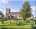
St Michael's Church
Church with parts from the 12th - 16th Centuries, restored in 1884-7 and the roof replaced partly in the 1970s and then fully in the early 2000s. Grade II listed - see https://cadwpublic-api.azurewebsites.net/reports/listedbuilding/FullReport?lang=&id=1943.
Image: © Ian Capper
Taken: 21 Feb 2022
0.05 miles
7
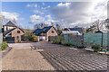
Cwrt Mihangel
Small cul-de-sac opposite The Skirrid Inn. In the right background is Y Skirrid.
Image: © Ian Capper
Taken: 21 Feb 2022
0.05 miles
8
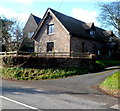
The Tythe Barn, Llanvihangel Crucorney
Located at the edge of the village church. http://www.geograph.org.uk/photo/3846110 Now in residential use, the tythe (or tithe) barn formerly held a parson's corn or other tithes paid in kind. Tithe (from an Old English word cognate with tenth) was one tenth of the annual produce of agriculture formerly taken as a tax, originally in kind, for the support of the church and clergy.
Image: © Jaggery
Taken: 19 Feb 2012
0.05 miles
9
St Michael's church, Llanvihangel Crucorney
Image: © Ruth Sharville
Taken: 1 Nov 2014
0.05 miles
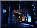
10
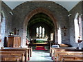
St. Michael's church, Llanvihangel Crucorney (interior)
Image: © Ruth Sharville
Taken: 1 Nov 2014
0.05 miles