IMAGES TAKEN NEAR TO
Triley, ABERGAVENNY, NP7 8DE
Introduction
This page details the photographs taken nearby to NP7 8DE by members of the Geograph project.
The Geograph project started in 2005 with the aim of publishing, organising and preserving representative images for every square kilometre of Great Britain, Ireland and the Isle of Man.

There are currently over 7.5m images from over14,400 individuals and you can help contribute to the project by visiting https://www.geograph.org.uk
Image Map
Images are licensed for reuse under creativecommons.org/licenses/by-sa/2.0
Notes
- Clicking on the map will re-center to the selected point.
- The higher the marker number, the further away the image location is from the centre of the postcode.
Image Listing (15 Images Found)
Images are licensed for reuse under creativecommons.org/licenses/by-sa/2.0
Image
Details
Distance
1
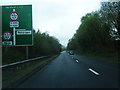
Hereford Road reaches the A465, Triley Mill
The (old) Hereford Road, from Abergavenny and Mardy, reaches the A465 junction.
Turn left http://www.geograph.org.uk/photo/2587776 for Llanvihangel and Hereford, right http://www.geograph.org.uk/photo/2587780 for Abergavenny.
Pentwyn Farm is in the background.
Image: © Jaggery
Taken: 1 Sep 2011
0.03 miles
2
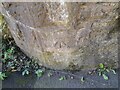
Ordnance Survey Cut Mark
This OS cut mark can be found on the south buttress of the railway bridge. It marks a point 114.099m above mean sea level.
Image: © Adrian Dust
Taken: 23 Sep 2022
0.04 miles
3
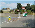
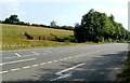
Road to Hereford from Triley Mill
Viewed from the (old) Hereford Road junction. The A465 heads towards Hereford, about 20 miles away.
Image: © Jaggery
Taken: 1 Sep 2011
0.06 miles
4
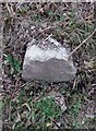
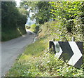
Old Milestone by Hereford Road, Lantilio Pertholey Parish
By the UC road (was A465), in parish of Lantilio Pertholey (Monmouthshire District), Triley Mill, opposite layby and railway, West side of road.
Inscription once read:- : (Abergavenny / 2) :
Surveyed
Milestone Society National ID: MON_AGHF02
Image: © Milestone Society
Taken: Unknown
0.06 miles
5
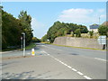
The A road from Triley Mill to Abergavenny
Viewed from the junction with (old) Hereford Road, which leads to Mardy and Abergavenny. The A465 seen here gives a quicker route south to Abergavenny, passing to the east of Mardy.
Image: © Jaggery
Taken: 1 Sep 2011
0.08 miles
6
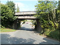
Triley Mill railway bridge
Hereford Road, from Abergavenny and Mardy, passes under the bridge carrying the Welsh Marches railway. The triangular sign on the bridge shows 14" 6'. The metric headroom (4.42 metres) is not shown.
Ahead is the A465 junction. http://www.geograph.org.uk/photo/2587788
Image: © Jaggery
Taken: 1 Sep 2011
0.08 miles
7
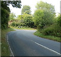
Sharp bend ahead, Hereford Road, Triley Mill
Immediately beyond the bend on the right is the railway bridge http://www.geograph.org.uk/photo/2587808 at Triley Mill.
A side road joins Hereford Road from the left, near the white arrows sign. There is a mirror http://www.geograph.org.uk/photo/2587827 on the sign's left chevron (arrow) to give drivers a view of the side road.
Image: © Jaggery
Taken: 1 Sep 2011
0.08 miles
8
Mirror on a sharp bend sign, Triley Mill
The mirror gives Hereford Road drivers approaching the bend http://www.geograph.org.uk/photo/2587819 a view of the side road seen here.
Image: © Jaggery
Taken: 1 Sep 2011
0.08 miles
9
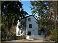
Triley Mill
Triley Mill was recorded as being sold as a working mill at auction at the Angel Hotel, Abergavenny in 1799, so it probably pre-dates that by some years.
Image: © Dan Schofield
Taken: 16 Nov 2007
0.11 miles