IMAGES TAKEN NEAR TO
Old Monmouth Road, ABERGAVENNY, NP7 8BU
Introduction
This page details the photographs taken nearby to Old Monmouth Road, NP7 8BU by members of the Geograph project.
The Geograph project started in 2005 with the aim of publishing, organising and preserving representative images for every square kilometre of Great Britain, Ireland and the Isle of Man.

There are currently over 7.5m images from over14,400 individuals and you can help contribute to the project by visiting https://www.geograph.org.uk
Image Map
Images are licensed for reuse under creativecommons.org/licenses/by-sa/2.0
Notes
- Clicking on the map will re-center to the selected point.
- The higher the marker number, the further away the image location is from the centre of the postcode.
Image Listing (9 Images Found)
Images are licensed for reuse under creativecommons.org/licenses/by-sa/2.0
Image
Details
Distance
1
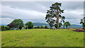
Scots Pine in a field
Sugarloaf/Y Fal and The Skirrid can be seen in the distance either side.
Image: © Jonathan Billinger
Taken: 5 Jul 2022
0.05 miles
2
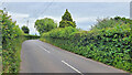
B4233 towards Ross-on-Wye
Looking east.
Image: © Jonathan Billinger
Taken: 5 Jul 2022
0.07 miles
3
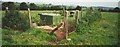
ROC Bunker - Abergavenny, Monmouthshire.
Nuclear observation bunker built for Royal Observer Corps and now derelict. One of more than 1500 that were built all around the UK.
Image: © Gary Sutherland
Taken: 16 Sep 2000
0.15 miles
4
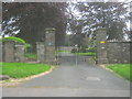
The entrance to Tredilion Park
With the Black Mountains in the distance.
Image: © Jennifer Luther Thomas
Taken: 8 Dec 2006
0.18 miles
5
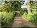
Farm Track near White Horse Farm
Looking north-westward from Abergavenny Fundamental Bench Mark. See : http://www.geograph.org.uk/photo/5208838
Image: © Peter Wood
Taken: 19 Oct 2016
0.18 miles
6
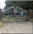
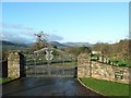
Ornate gates at the entrance to Tredilion Park, Monmouthshire
Set back from the north side of the B4233. In August 2024 the notice on a gate shows
PRIVATE PROPERTY
Please DO NOT ENTER the Tredilion Park grounds
CCTV is in operation and trespassers will be prosecuted
Image: © Jaggery
Taken: 11 Aug 2024
0.18 miles
7
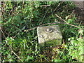
Ordnance Survey Fundamental Bench Mark - Abergavenny
This can be found beside a track near White Horse Farm.
For more detail see : http://www.bench-marks.org.uk/bm993
Image: © Peter Wood
Taken: 19 Oct 2016
0.19 miles
8
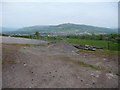
Abergavenny from near White Horse Farm
A nice view of Abergavenny, though the Sugar Loaf is obscured.
Image: © Jeremy Bolwell
Taken: 18 May 2012
0.20 miles
9
Ornamental gates at the entrance to Tredilion Park
Near to the B4233
Image: © Peter Robinson
Taken: 27 May 2015
0.20 miles