IMAGES TAKEN NEAR TO
Llanddewi Rhydderch, ABERGAVENNY, NP7 8BN
Introduction
This page details the photographs taken nearby to NP7 8BN by members of the Geograph project.
The Geograph project started in 2005 with the aim of publishing, organising and preserving representative images for every square kilometre of Great Britain, Ireland and the Isle of Man.

There are currently over 7.5m images from over14,400 individuals and you can help contribute to the project by visiting https://www.geograph.org.uk
Image Map
Images are licensed for reuse under creativecommons.org/licenses/by-sa/2.0
Notes
- Clicking on the map will re-center to the selected point.
- The higher the marker number, the further away the image location is from the centre of the postcode.
Image Listing (7 Images Found)
Images are licensed for reuse under creativecommons.org/licenses/by-sa/2.0
Image
Details
Distance
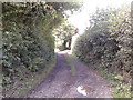
1
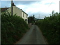
Looking along lane towards the house
Image: © Nick Mutton 01329 000000
Taken: 16 Sep 2007
0.04 miles
2
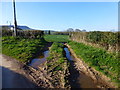
Field entrance north-west of Llanvapley
Image: © Ruth Sharville
Taken: 7 Apr 2015
0.05 miles
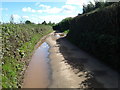
3
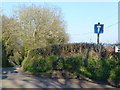
Junction at the road to Mill Farm, near Llanvapley
Image: © Ruth Sharville
Taken: 7 Apr 2015
0.10 miles
4
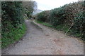
Byway to Parsonage Farm
Byway and track to Parsonage Farm and Llandewi.
Image: © Philip Halling
Taken: 15 Mar 2014
0.19 miles
7
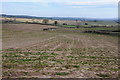
Arable land near Parc-gwyn
Arable land near Parc-gwyn north of Llanvapley.
Image: © Philip Halling
Taken: 15 Mar 2014
0.24 miles