IMAGES TAKEN NEAR TO
Cae Parc, ABERGAVENNY, NP7 8AN
Introduction
This page details the photographs taken nearby to Cae Parc, NP7 8AN by members of the Geograph project.
The Geograph project started in 2005 with the aim of publishing, organising and preserving representative images for every square kilometre of Great Britain, Ireland and the Isle of Man.

There are currently over 7.5m images from over14,400 individuals and you can help contribute to the project by visiting https://www.geograph.org.uk
Image Map
Images are licensed for reuse under creativecommons.org/licenses/by-sa/2.0
Notes
- Clicking on the map will re-center to the selected point.
- The higher the marker number, the further away the image location is from the centre of the postcode.
Image Listing (69 Images Found)
Images are licensed for reuse under creativecommons.org/licenses/by-sa/2.0
Image
Details
Distance
1
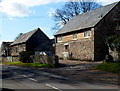
Mill Stone Barn, Llanvihangel Crucorney
Former farm building converted to residential use.
Image: © Jaggery
Taken: 19 Feb 2012
0.03 miles
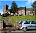
2
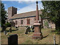
Llanvihangel Crucorney Church
The church is dedicated to St Michael & All Angels.
Image: © Philip Halling
Taken: 6 Aug 2006
0.06 miles
3
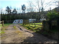
Pen-y-dre Caravan and Camp Site, Llanvihangel Crucorney
Located opposite Pen-y-dre Farm.
Image: © Jaggery
Taken: 19 Feb 2012
0.08 miles
4
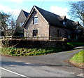
The Tythe Barn, Llanvihangel Crucorney
Located at the edge of the village church. http://www.geograph.org.uk/photo/3846110 Now in residential use, the tythe (or tithe) barn formerly held a parson's corn or other tithes paid in kind. Tithe (from an Old English word cognate with tenth) was one tenth of the annual produce of agriculture formerly taken as a tax, originally in kind, for the support of the church and clergy.
Image: © Jaggery
Taken: 19 Feb 2012
0.08 miles
5
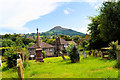
The churchyard, Llanfihangel Crucorney
The unmistakable Skirrid dominates the view.
Image: © Philip Pankhurst
Taken: 2 Aug 2014
0.08 miles
6
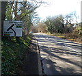
A465 junction ahead, Llanvihangel Crucorney
Viewed along the road that used to be part of the A465 before the construction
of a straighter 800 metre long section of road that bypassed the centre of the village.
Image: © Jaggery
Taken: 19 Feb 2012
0.09 miles
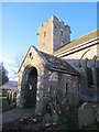
7
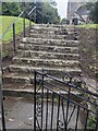
Churchyard entrance steps, Llanvihangel Crucorney, Monmouthshire
Steps ascend to St Michael's churchyard in the Church in Wales Diocese of Monmouth.
Image: © Jaggery
Taken: 22 Sep 2024
0.09 miles
8
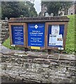
Parish of Crucorney Fawr noticeboards, Monmouthshire
Near steps leading up to St Michael's churchyard in Llanvihangel Crucorney.
In September 2024 the board on the left shows
WEEKLY PARISH SUNDAY SERVICES
Holy Eucharist
8.30am at St David's Church Llanthony
(1st Sunday of the month autumn / winter)
9.30am at St Martin's Church Cwmyoy
11am here at St Michael's Church.
Image: © Jaggery
Taken: 22 Sep 2024
0.10 miles
9
Steps up to the church, Llanvihangel Crucorney
An entrance to the Church of St Michael and All Angels.
Image: © Jaggery
Taken: 19 Feb 2012
0.10 miles
10
St Michael's & All Angels Church
There is an OS cut mark on the porch.
Image: © Adrian Dust
Taken: 11 Jan 2014
0.10 miles