IMAGES TAKEN NEAR TO
Bryn-y-Gwenin, ABERGAVENNY, NP7 8AA
Introduction
This page details the photographs taken nearby to NP7 8AA by members of the Geograph project.
The Geograph project started in 2005 with the aim of publishing, organising and preserving representative images for every square kilometre of Great Britain, Ireland and the Isle of Man.

There are currently over 7.5m images from over14,400 individuals and you can help contribute to the project by visiting https://www.geograph.org.uk
Image Map
Images are licensed for reuse under creativecommons.org/licenses/by-sa/2.0
Notes
- Clicking on the map will re-center to the selected point.
- The higher the marker number, the further away the image location is from the centre of the postcode.
Image Listing (15 Images Found)
Images are licensed for reuse under creativecommons.org/licenses/by-sa/2.0
Image
Details
Distance
1
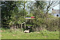
Footbridge and stile to road, Brynygwenin
The white building is part of Pontgarreg Farm. The public footpath, behind the camera, runs across the corner of the field, but the exit to the Old Ross Road was difficult.
Image: © M J Roscoe
Taken: 23 Apr 2021
0.02 miles
2

Stubble field at Brynygwenin
One of many paths that criss-cross this area.
Image: © Jeremy Bolwell
Taken: 21 Nov 2013
0.07 miles
3
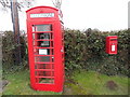
K6 Telephone Box and Post Box at Llanddewi Skirrid
This photo shows a red K6 telephone box and postbox on the B4521 road near Bryn-y-Gwenin NP7 8AA. The telephone box has a white notice fixed on it indicating that it will shortly be taken out due to lack of usage. The red post box has a metal post covered by the creeping ivy plant.
Image: © David Hillas
Taken: 10 Feb 2017
0.11 miles
4
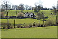
Spring Cottage, Brynygwenin
The Mynachdy Brook, indicated by line of bushes, runs across the picture.
Image: © M J Roscoe
Taken: 23 Apr 2021
0.12 miles
5
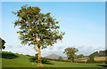
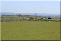
Trees in a field
The field is on the north side of the single road village of Brynygwenin; the mountain cone in the distance is the unusually named Sugar Loaf.
Image: © Trevor Littlewood
Taken: 10 Oct 2016
0.15 miles
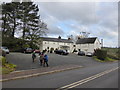
6
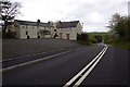
The Walnut Tree Inn and B4521 at Llanddewi Skirrid
The recently refurbished Walnut Tree Inn is now home to celebrity chef Shaun Hill.
Image: © Roger Davies
Taken: 27 Apr 2008
0.15 miles
7
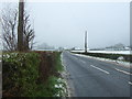
Old Ross Road towards Skenfrith
Looking east on the B4521.
Image: © JThomas
Taken: 4 Apr 2019
0.16 miles
8
Field on the east of Brynygwenin
A public footpath runs across the field from the camera to a stile (centre) just to the left of the pylon and on to Wern-Gochlyn just visible beyond the pylon. The line of bushes to the left marks the course of Mynachdy Brook.
Image: © M J Roscoe
Taken: 23 Apr 2021
0.16 miles
9
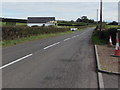
Old Ross Road, Llanddewi Skirrid
Looking east along the B4521 Old Ross Road towards the centre of Llanddewi Skirrid.
Image: © Jaggery
Taken: 8 Oct 2017
0.17 miles
10
The Walnut Tree at Llanddewi Skirrid near Abergavenny
A great restaurant with rooms - Shaun Hill is the owner and chef and the service, setting, food and wines are of top quality and this is a destination eatery with people flocking from all over to sample its seasonal menu. Today some walkers arrive after a local walk.
Image: © Jeremy Bolwell
Taken: 21 Nov 2013
0.18 miles