1
Derelict former tin chapel, Cae Pen y Dre, Abergavenny
An apparently long-abandoned place of worship is located at the western end of a street named Cae Pen y Dre. There was no evidence remaining to indicate the name of the former church or chapel.
Image: © Jaggery
Taken: 22 Oct 2010
0.02 miles
2
Cae Pen y Dre Close, Abergavenny
Cul-de-sac at the western end of Cae Pen y Dre, accessed by road from Union Road East.
Image: © Jaggery
Taken: 30 Sep 2018
0.06 miles
3
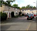
Western end of Cae Pen y Dre, Abergavenny
Connecting with Union Road East behind the camera, Cae Pen y Dre ends at
the edge of Cae Pen y Dre Close retirement housing in the background on the left.
Image: © Jaggery
Taken: 30 Sep 2018
0.07 miles
4
Footbridge at the western end of Union Road East, Abergavenny
The footbridge crosses above the A4143, giving pedestrian access to Hatherleigh Place and Union Road West.
Image: © Jaggery
Taken: 22 Oct 2010
0.07 miles
5
Derelict former place of worship, Cae Pen y Dre, Abergavenny
The corrugated iron building appears long derelict in September 2018.
Coflein records that this was a Mission Hall, but does not state when the
building first opened for worship nor when it was abandoned.
Image: © Jaggery
Taken: 30 Sep 2018
0.07 miles
6
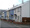
Blue and white new houses, Cae Pen y Dre, Abergavenny
Recently-built houses on a street named Cae Pen y Dre, viewed from the corner of Union Road East.
Image: © Jaggery
Taken: 22 Oct 2010
0.08 miles
7
Older houses, Cae Pen y Dre, Abergavenny
Cae Pen y Dre contains recently built houses http://www.geograph.org.uk/photo/2156865 and older ones, such as these, adjacent to a derelict chapel http://www.geograph.org.uk/photo/2156877 (just out of shot on the right).
Image: © Jaggery
Taken: 22 Oct 2010
0.08 miles
8
Row of houses, Cae Pen y Dre, Abergavenny
The road named Cae Pen y Dre is on the south side of Union Road East.
Image: © Jaggery
Taken: 30 Sep 2018
0.08 miles
9
Castle Meadows at Abergavenny prepares for Wales National Eisteddfod
Taking shape.
Image: © Jeremy Bolwell
Taken: 17 Jul 2016
0.09 miles
10
Abergavenny : Merthyr Road houses adjacent to north bank of the Usk
Houses located opposite a roundabout on Merthyr Road, about 100 metres north of the River Usk.
The house on the left was built (or possibly rebuilt) recently.
Image: © Jaggery
Taken: 22 Oct 2010
0.10 miles


