IMAGES TAKEN NEAR TO
Castle Meadows Park, Merthyr Road, ABERGAVENNY, NP7 7RZ
Introduction
This page details the photographs taken nearby to Castle Meadows Park, Merthyr Road, NP7 7RZ by members of the Geograph project.
The Geograph project started in 2005 with the aim of publishing, organising and preserving representative images for every square kilometre of Great Britain, Ireland and the Isle of Man.

There are currently over 7.5m images from over14,400 individuals and you can help contribute to the project by visiting https://www.geograph.org.uk
Image Map
Images are licensed for reuse under creativecommons.org/licenses/by-sa/2.0
Notes
- Clicking on the map will re-center to the selected point.
- The higher the marker number, the further away the image location is from the centre of the postcode.
Image Listing (170 Images Found)
Images are licensed for reuse under creativecommons.org/licenses/by-sa/2.0
Image
Details
Distance
1
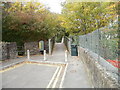
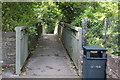
Footbridge at the western end of Union Road East, Abergavenny
The footbridge crosses above the A4143, giving pedestrian access to Hatherleigh Place and Union Road West.
Image: © Jaggery
Taken: 22 Oct 2010
0.02 miles
2
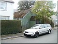
Derelict former tin chapel, Cae Pen y Dre, Abergavenny
An apparently long-abandoned place of worship is located at the western end of a street named Cae Pen y Dre. There was no evidence remaining to indicate the name of the former church or chapel.
Image: © Jaggery
Taken: 22 Oct 2010
0.05 miles
3
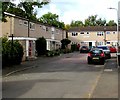
Cae Pen y Dre Close, Abergavenny
Cul-de-sac at the western end of Cae Pen y Dre, accessed by road from Union Road East.
Image: © Jaggery
Taken: 30 Sep 2018
0.05 miles
4
Western end of Cae Pen y Dre, Abergavenny
Connecting with Union Road East behind the camera, Cae Pen y Dre ends at
the edge of Cae Pen y Dre Close retirement housing in the background on the left.
Image: © Jaggery
Taken: 30 Sep 2018
0.06 miles
5
Footbridge over A4143, Abergavenny
The bridge leads from Union Road East to Hatherleigh Place and Union Road West. At one time there was a road bridge here across what was a railway line and Union Road would have been one thoroughfare.
Image: © M J Roscoe
Taken: 14 Sep 2017
0.07 miles
6
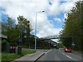
Footbridge over A4143, Abergavenny
The A4143 uses the trackbed of a former railway; the bridge links two parts of a street severed and diverted when the road was constructed
Image: © David Smith
Taken: 28 Apr 2023
0.07 miles
7

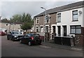
Stone houses, Union Road East, Abergavenny
On the approach to the footbridge https://www.geograph.org.uk/photo/2156937 at the northwest end of the road.
Image: © Jaggery
Taken: 30 Sep 2018
0.07 miles
8

Change in house type, Union Road East, Abergavenny
On the approach to the footbridge https://www.geograph.org.uk/photo/2156937 at the northwest end of the road.
Image: © Jaggery
Taken: 30 Sep 2018
0.07 miles
9
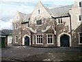
The Old Workhouse, Abergavenny
Grade II listed building located on Hatherleigh Place. It was built during 1837-1838 as the Abergavenny Union Workhouse, under the terms of the 1834 Poor Law Reform Act. It remained in use as the workhouse until about 1945. Since then it has been much altered, as it was put to various business uses. The remaining part, seen here, has been repaired and restored since 2000. It is the entrance block which once contained the admissions, administrative and warden's offices, and the boardroom for the Board of Guardians.
Image: © Jaggery
Taken: 22 Oct 2010
0.08 miles
10
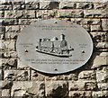
Railway plaque, A4143, Abergavenny
Affixed to a wall alongside the A4143 is a plaque with a representation of an LMS 0-6-2T (tank) locomotive. The surrounding text is
This Plaque is to commemorate the railway people of Abergavenny
Abergavenny 1860 (representation of locomotive) Merthyr 1960.
Near this spot stood the local engine sheds which once housed nearly one hundred steam engines. [end of text].
The locomotive depicted is a Webb Coal Tank, which would have been a common sight in this area in the first half of the 20th century. They were introduced by the LNWR (London and North Western Railway) in 1881. They were designed by F.W. Webb with distinctive cheaply-produced cast iron wheels and H-section spokes. 300 were built between 1881 and 1899. At the 1923 grouping, the locomotives became part of the London Midland and Scottish Railway (LMS). Only one Webb Coal Tank has been preserved. http://www.geograph.org.uk/photo/4738685
About 400 metres to the NE is the site of the former Brecon Road railway station, opened in 1862, closed in 1958.
Image: © Jaggery
Taken: 22 Oct 2010
0.08 miles