IMAGES TAKEN NEAR TO
Hillside, ABERGAVENNY, NP7 7RS
Introduction
This page details the photographs taken nearby to Hillside, NP7 7RS by members of the Geograph project.
The Geograph project started in 2005 with the aim of publishing, organising and preserving representative images for every square kilometre of Great Britain, Ireland and the Isle of Man.

There are currently over 7.5m images from over14,400 individuals and you can help contribute to the project by visiting https://www.geograph.org.uk
Image Map
Images are licensed for reuse under creativecommons.org/licenses/by-sa/2.0
Notes
- Clicking on the map will re-center to the selected point.
- The higher the marker number, the further away the image location is from the centre of the postcode.
Image Listing (24 Images Found)
Images are licensed for reuse under creativecommons.org/licenses/by-sa/2.0
Image
Details
Distance
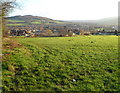
1
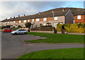
Rother Avenue houses, Abergavenny
Houses on the north side of Rother Avenue, looking in the direction of Underhill Crescent.
Image: © Jaggery
Taken: 7 Dec 2011
0.08 miles
2
Roadside stones, Deri Road, Abergavenny
Presumably the purpose of the stones enclosed in metal meshing is to prevent the bank collapsing across the roadway.
Image: © Jaggery
Taken: 7 Dec 2011
0.11 miles
3
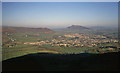
Overlooking Abergavenny
From the minor road between Blorenge and Gilwern Hill at Pwll-du looking north-east. The whole town is in view and beyond it the distinctive ridge of The Skirrid (Ysgyryd Fawr). Just to the left of the town is the dome-shaped ridge of Twyn-yr-allt, which leads up to the Sugar Loaf, which is just out of shot on the left. Below is the Usk valley.
Image: © Trevor Rickard
Taken: Unknown
0.12 miles
4
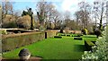
The Hill Gardens, Abergavenny
This is the Late Georgian walled garden created by John Wedgwood around 1830. Wedgwood was part of the ceramics dynasty, a renowned horticulturist, acquaintance of Darwin and founding member of the Royal Horticultural Society.
Not open to the public at present, it is contained within an estate including gated housing, woodland and converted college buildings.
Image: © Jonathan Billinger
Taken: 4 Feb 2020
0.12 miles
6
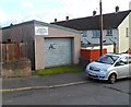
Abergavenny Community House Auto Maintenance Project
Located in a Rother Avenue garage. Abergavenny Community House is a registered charity.
Image: © Jaggery
Taken: 7 Dec 2011
0.14 miles
7
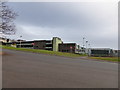
Part of King Henry VIII School at Abergavenny
Lower School as it was known in my day, as it educated the new entrants from age 11 years up to 15 years - a fine seat of learning with a large intake of pupils from the town and surrounding rural villages and farms. Some 1,500 pupils in my era if I recall correctly - and every ability range and personality type seemed to be represented in this educational melting pot. Every year the school could claim a few Oxbridge entrants as well as a few expelled for achievements at the opposite end of the scale. Never a dull moment.
I can recall snowballing the buses dropping off kids from Govilon, Llanfoist and Llanellen, Grosmont, Forest Coal Pit and Llanthony and Cross Ash - I also recall fights, teachers, illicit smoking and the daily walk to and from school. Yes, walk. In all weathers.
Image: © Jeremy Bolwell
Taken: 14 Dec 2013
0.14 miles
8
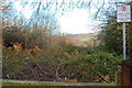
No public right of way from the SE side of Deri Road, Abergavenny
The sign is alongside a gate at the edge of Deri Road. There was no path or track discernible in this early December view. A summer view would have shown much more vegetation here, so the sign is achieving its objective by deterring would-be walkers thus allowing nature to obliterate any trace of a path.
Image: © Jaggery
Taken: 7 Dec 2011
0.15 miles
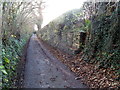
9
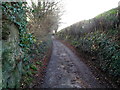
Narrow roadway, no pavements and steep edges, Deri Road, Abergavenny
This is not a place for walkers (or indeed motorists!) to meet an oncoming vehicle. Fortunately my walk along this section of Deri Road was uneventful.
Image: © Jaggery
Taken: 7 Dec 2011
0.15 miles
10
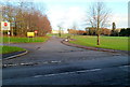
Western edge of King Henry VIII school, Abergavenny
Viewed from a road named Pen-y-pound. The No Entry signs show that this is an exit road for vehicles.
Image: © Jaggery
Taken: 7 Dec 2011
0.16 miles