IMAGES TAKEN NEAR TO
Cwmyoy, ABERGAVENNY, NP7 7NT
Introduction
This page details the photographs taken nearby to NP7 7NT by members of the Geograph project.
The Geograph project started in 2005 with the aim of publishing, organising and preserving representative images for every square kilometre of Great Britain, Ireland and the Isle of Man.

There are currently over 7.5m images from over14,400 individuals and you can help contribute to the project by visiting https://www.geograph.org.uk
Image Map
Images are licensed for reuse under creativecommons.org/licenses/by-sa/2.0
Notes
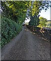
- Clicking on the map will re-center to the selected point.
- The higher the marker number, the further away the image location is from the centre of the postcode.
Image Listing (135 Images Found)
Images are licensed for reuse under creativecommons.org/licenses/by-sa/2.0
Image
Details
Distance
1
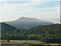
View of the Skirrid / Ysgyryd Fawr from Cwmyoy
The mountain, an enigmatic outlier of the Black Mountain range, is wreathed in morning mist.
Image: © Jeremy Bolwell
Taken: 8 Sep 2012
0.05 miles
2
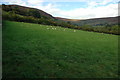
Cwm Iau
Grazing land in Cwm Iau to the east of the small village of Cwmyoy.
Image: © Philip Halling
Taken: 16 Oct 2010
0.09 miles
3
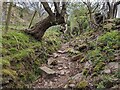
Path to Y Graig (Cwmyoy)
This path leads the walker to the 349m (1,145ft) summit of Y Graig, situated west from this viewpoint.
Image: © Fabian Musto
Taken: 28 Apr 2022
0.10 miles
4
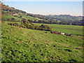
Farmland east of Cwmyoy
View east towards the farm buildings at Perthi-crwm below Hatterrall Hill on the left. A mix of cattle and sheep farming here.
Image: © Trevor Rickard
Taken: 11 Oct 2010
0.10 miles
5
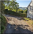
Junction in Cwmyoy, Monmouthshire
A flattish road past the edge of St Martin's churchyard joins this https://www.geograph.org.uk/photo/7258641 steep road.
Image: © Jaggery
Taken: 7 Aug 2022
0.11 miles
6
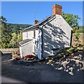
Shadows on a white house, Cwmyoy, Monmouthshire
The house is near St Martin's churchyard.
Image: © Jaggery
Taken: 7 Aug 2022
0.12 miles
7
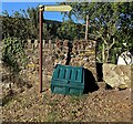
Longtown direction and distance sign, Cwmyoy, Monmouthshire
The sign located near St Martin's churchyard indicates a footpath route extending for 7.2km to Longtown (Herefordshire). The distance in miles (4) is not shown.
Image: © Jaggery
Taken: 7 Aug 2022
0.12 miles
8
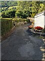
Steep descent, Cwmyoy, Monmouthshire
An unnamed minor road passes this https://www.geograph.org.uk/photo/7258637 house.
Image: © Jaggery
Taken: 7 Aug 2022
0.12 miles
9
Minor road between hedge and wall, Cwmyoy, Monmouthshire
A perimeter wall of St Martin's churchyard is on the right.
Image: © Jaggery
Taken: 7 Aug 2022
0.13 miles
10
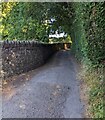
Minor road between wall and hedge, Cwmyoy, Monmouthshire
A perimeter wall of St Martin's churchyard is on the left.
Image: © Jaggery
Taken: 7 Aug 2022
0.13 miles