IMAGES TAKEN NEAR TO
Cwmyoy, ABERGAVENNY, NP7 7NS
Introduction
This page details the photographs taken nearby to NP7 7NS by members of the Geograph project.
The Geograph project started in 2005 with the aim of publishing, organising and preserving representative images for every square kilometre of Great Britain, Ireland and the Isle of Man.

There are currently over 7.5m images from over14,400 individuals and you can help contribute to the project by visiting https://www.geograph.org.uk
Image Map
Images are licensed for reuse under creativecommons.org/licenses/by-sa/2.0
Notes
- Clicking on the map will re-center to the selected point.
- The higher the marker number, the further away the image location is from the centre of the postcode.
Image Listing (136 Images Found)
Images are licensed for reuse under creativecommons.org/licenses/by-sa/2.0
Image
Details
Distance
1
Line spur pole, Cwmyoy, Monmouthshire
Located behind a house, the line spur pole is a rural part of the Western Power Distribution electricity supply infrastructure.
Image: © Jaggery
Taken: 7 Aug 2022
0.01 miles
2
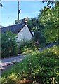
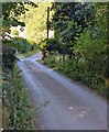
Ascent into gloom, Cwmyoy, Monmouthshire
The tree-dominated road ahead is gloomy on a sunny day in early August 2022. Ahead for St Martin's Church.
Image: © Jaggery
Taken: 7 Aug 2022
0.02 miles
3
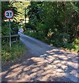
3T road sign, Cwmyoy, Monmouthshire
The sign indicates a 3 tons maximun vehicle weight on the weak bridge ahead. https://www.geograph.org.uk/photo/7248270
Image: © Jaggery
Taken: 7 Aug 2022
0.02 miles
4
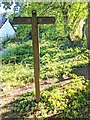
Wooden signpost for walkers, Cwmyoy, Monmouthshire
Left for Llanthony, right for (other parts of) Cwmyoy. A yellow / golden depiction of a walker is on each direction sign.
Image: © Jaggery
Taken: 7 Aug 2022
0.02 miles
5
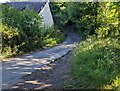
Road on a weak bridge, Cwmyoy, Monmouthshire
The bridge carries a minor road over the River Honddu. A 3T sign https://www.geograph.org.uk/photo/7248274 behind the camera indicates a 3 tons vehicle weight limit on the bridge.
Image: © Jaggery
Taken: 7 Aug 2022
0.03 miles
6
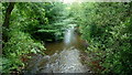
River Honddu at Neuadd, 2
Looking upstream.
Image: © Jonathan Billinger
Taken: 5 Jul 2016
0.03 miles
7
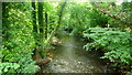
River Honddu at Neuadd, 1
Well-wooded banks, looking downstream.
Image: © Jonathan Billinger
Taken: 5 Jul 2016
0.04 miles
8
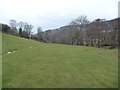
Riverside pastures near Cwmyoy
A mole-free-zone runs through the area where farm vehicles and walkers cross the meadow.
Image: © Jeremy Bolwell
Taken: 30 Mar 2013
0.07 miles
9
Narrow part of a minor road, Cwmyoy, Monmouthshire
Ahead for St Martin's Church.
Behind the camera for this https://www.geograph.org.uk/photo/7248165 road.
Image: © Jaggery
Taken: 7 Aug 2022
0.08 miles
10
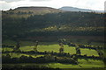
View across the Vale of Ewyas
View across the Vale of Ewyas above Cwmyoy to Twyn y Gaer with the summit of Sugar Loaf.
Image: © Philip Halling
Taken: 16 Oct 2010
0.08 miles