IMAGES TAKEN NEAR TO
Brynarw Estate, ABERGAVENNY, NP7 7ND
Introduction
This page details the photographs taken nearby to Brynarw Estate, NP7 7ND by members of the Geograph project.
The Geograph project started in 2005 with the aim of publishing, organising and preserving representative images for every square kilometre of Great Britain, Ireland and the Isle of Man.

There are currently over 7.5m images from over14,400 individuals and you can help contribute to the project by visiting https://www.geograph.org.uk
Image Map
Images are licensed for reuse under creativecommons.org/licenses/by-sa/2.0
Notes
- Clicking on the map will re-center to the selected point.
- The higher the marker number, the further away the image location is from the centre of the postcode.
Image Listing (59 Images Found)
Images are licensed for reuse under creativecommons.org/licenses/by-sa/2.0
Image
Details
Distance
1
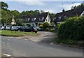
Brynarw, Stanton, Monmouthshire
Houses set back from the east side of the road towards Llanthony.
Image: © Jaggery
Taken: 22 May 2022
0.00 miles
2
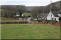
Stanton hamlet
A small hamlet on the road to the Vale of Eywas. The hedge, mid picture, is on the minor road to Llanbedr. The distant white building behind trees is Llwyncelyn Farm.
Image: © M J Roscoe
Taken: 2 Feb 2022
0.02 miles
3
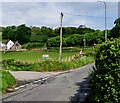
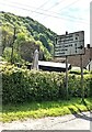
Junction in Stanton, Monmouthshire
Ahead on the right for Cwmyoy, Llanthony and Hay-on-Wye.
Turn left for Forest Coal Pit (1¾ (miles)), Partrishow (2¾), Llanbedr (5).
Image: © Jaggery
Taken: 15 May 2022
0.03 miles
4
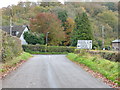
Approaching the road junction at Stanton
Image: © Ruth Sharville
Taken: 1 Nov 2014
0.04 miles
5
Direction and distances sign, Stanton, Monmouthshire
Ahead for Llanvihangel (1¼ (miles)) and Abergavenny (6).
Right for Forest Coal Pit (2), Partrishow (3), Llanbedr (5).
Image: © Jaggery
Taken: 15 May 2022
0.04 miles
6
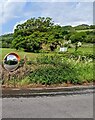
Roadside mirror, Stanton, Monmouthshire
Alongside the unclassified road from Llanvihangel Crucorney to Llanthony, the mirror is opposite a dead-end side road. https://www.geograph.org.uk/photo/7174300
Image: © Jaggery
Taken: 15 May 2022
0.04 miles
7
Dead-end side road, Stanton, Monmouthshire
On the east side of the unclassified road from Llanthony to Llanvihangel Crucorney in rural Monmouthshire.
Image: © Jaggery
Taken: 15 May 2022
0.04 miles
8
Road at Stanton
Road at Stanton heading towards Llanvihangel Crucorney
Image: © Shaun Ferguson
Taken: 10 May 2008
0.05 miles
9
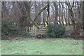
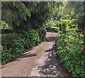
Stile into woodland next to Afon Honddu
Public footpath near Strawberry Cottage Wood.
Image: © M J Roscoe
Taken: 23 Jan 2020
0.06 miles
10
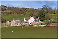
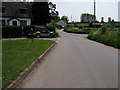
Towards Llwyn Celyn
Looking towards Llwyn Celyn from by Brynarw.
Image: © Ian Capper
Taken: 25 Feb 2022
0.06 miles