IMAGES TAKEN NEAR TO
Forest Coal Pit, ABERGAVENNY, NP7 7LL
Introduction
This page details the photographs taken nearby to NP7 7LL by members of the Geograph project.
The Geograph project started in 2005 with the aim of publishing, organising and preserving representative images for every square kilometre of Great Britain, Ireland and the Isle of Man.

There are currently over 7.5m images from over14,400 individuals and you can help contribute to the project by visiting https://www.geograph.org.uk
Image Map
Images are licensed for reuse under creativecommons.org/licenses/by-sa/2.0
Notes
- Clicking on the map will re-center to the selected point.
- The higher the marker number, the further away the image location is from the centre of the postcode.
Image Listing (9 Images Found)
Images are licensed for reuse under creativecommons.org/licenses/by-sa/2.0
Image
Details
Distance
1
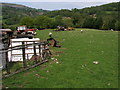
Field behind Chapel Farm Forest Coal Pit
A scrap yard in the field behind Chapel Farm Forest Coal Pit
Image: © Shaun Ferguson
Taken: 10 May 2008
0.02 miles
3
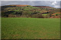
Patrishow Hill viewed from above Forest Coal Pit
Image: © Philip Halling
Taken: 25 Feb 2007
0.09 miles
4
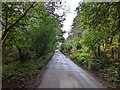
Dead end lane
Heading east towards Old Coalpit with foot access to Bryn Arw.
Image: © Jonathan Billinger
Taken: 7 Jun 2016
0.10 miles
5
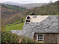
Re-roofing at Forest Coal Pit
The curiously named Forest Coal Pit among the lesser hill country of the south-eastern Black Mountains. Beyond the building work is the valley of the Grwyne Fawr.
Image: © Trevor Littlewood
Taken: 12 Apr 2005
0.13 miles
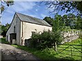
6
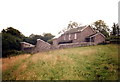
Hen Ysgol Forest Coal Pit Old School
Hen Ysgol Forest Coal Pit yn 1998. Mae Llwybr hirbell 'Ffordd y Cambrian' yn mynd heibio iddi.
Forest Coal Pit Old School in 1998. The 'Cambrian Way', a long distance path runs alongside it.
Image: © Alan Richards
Taken: 29 Jul 1998
0.14 miles
7
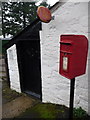
Forest Coal Pit: the post office and postbox № NP7 58
The hamlet of Forest Coal Pit can count itself fortunate still to have a post office. It is in this lean-to outbuilding of a cottage and operates more or less full-time hours. The actual name of the post office branch is "The Fforest" rather than Forest Coal Pit, although signposts in the area refer to both versions.
The postbox, a standard Elizabeth II-reign one, is emptied finally at 2pm on weekdays and at 11:30am on Saturdays.
Image: © Chris Downer
Taken: 21 Feb 2011
0.15 miles
8
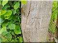
Ordnance Survey Cut Mark
This OS cut mark can be found on the wooden gatepost SW side of the road. It marks a point 243.758m above mean sea level.
Image: © Adrian Dust
Taken: 5 Jun 2023
0.21 miles
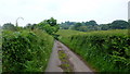
9
Road that used to be a railway line for construction of Grwyne Fawr reservoir
Image: © Rob Purvis
Taken: 26 Sep 2023
0.25 miles