IMAGES TAKEN NEAR TO
Bettws, ABERGAVENNY, NP7 7LF
Introduction
This page details the photographs taken nearby to NP7 7LF by members of the Geograph project.
The Geograph project started in 2005 with the aim of publishing, organising and preserving representative images for every square kilometre of Great Britain, Ireland and the Isle of Man.

There are currently over 7.5m images from over14,400 individuals and you can help contribute to the project by visiting https://www.geograph.org.uk
Image Map
Images are licensed for reuse under creativecommons.org/licenses/by-sa/2.0
Notes
- Clicking on the map will re-center to the selected point.
- The higher the marker number, the further away the image location is from the centre of the postcode.
Image Listing (11 Images Found)
Images are licensed for reuse under creativecommons.org/licenses/by-sa/2.0
Image
Details
Distance
1
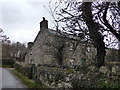
Cap-glas cottage
A picturesque little cottage at the roadside south of Bettws near Fforest Coalpit.
Image: © Jeremy Bolwell
Taken: 14 Dec 2013
0.02 miles
4
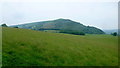
View to Bryn Arw
Looking north-east from the Bettws Lane near Great Gott.
Image: © Jonathan Billinger
Taken: 7 Jun 2016
0.19 miles
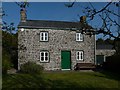
5
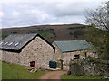
Great Gott
Farm buildings at Great Gott with Bryn Arw beyond.
Image: © Trevor Littlewood
Taken: 12 Apr 2005
0.19 miles
6
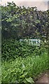
Partly obscured Bettws boundary sign, Monmouthshire
Sign at the southern edge of Bettws viewed in late May 2022. This Bettws is in rural Monmouthshire between Pantygelli to the south and Forest Coal Pit to the north.
Image: © Jaggery
Taken: 22 May 2022
0.19 miles
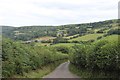
7
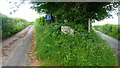
Fork in the lanes
Great Gott to the left, Bettws to the right.
Image: © Jonathan Billinger
Taken: 7 Jun 2016
0.20 miles
8
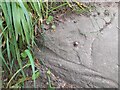
Ordnance Survey Rivet
This OS rivet can be found on the stile step NE side of the road. It marks a point 216.820m above mean sea level.
Image: © Adrian Dust
Taken: 5 Jun 2023
0.20 miles
9
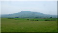
View to Ysgyryd Fawr
The distinctive outline of The Skirrid from Bettws Lane.
Image: © Jonathan Billinger
Taken: 7 Jun 2016
0.21 miles
10
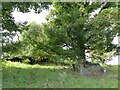
Remains of a building overgrown by trees
Image: © Rob Purvis
Taken: 21 Sep 2021
0.21 miles