IMAGES TAKEN NEAR TO
Llwyn Du, ABERGAVENNY, NP7 7HY
Introduction
This page details the photographs taken nearby to NP7 7HY by members of the Geograph project.
The Geograph project started in 2005 with the aim of publishing, organising and preserving representative images for every square kilometre of Great Britain, Ireland and the Isle of Man.

There are currently over 7.5m images from over14,400 individuals and you can help contribute to the project by visiting https://www.geograph.org.uk
Image Map
Images are licensed for reuse under creativecommons.org/licenses/by-sa/2.0
Notes
- Clicking on the map will re-center to the selected point.
- The higher the marker number, the further away the image location is from the centre of the postcode.
Image Listing (15 Images Found)
Images are licensed for reuse under creativecommons.org/licenses/by-sa/2.0
Image
Details
Distance
1
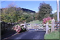
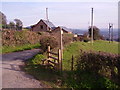
Gate to Sunnyvale Farm
Near Abergavenny
Image: © Andrew Abbott
Taken: 30 Oct 2021
0.12 miles
2
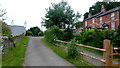
Cottages at Sunny Vale
Pen-y-pound road north of Abergavenny.
Image: © Jonathan Billinger
Taken: 10 Jun 2016
0.14 miles
3
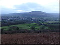
Part of Abergavenny from the Deri
Nevill Hall stands out all lit up on a winter's afternoon.
Image: © Jeremy Bolwell
Taken: 27 Dec 2013
0.14 miles
4
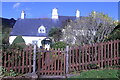
Sunnyvale Farm
Category II listed. Listing reference 86803.
Probably c1600 in origin when it was a 2-unit house with cowhouse and cross-passage between, and thus conforming to the plan of a Welsh longhouse. The conversion to a 3-room house may have come quite early in the C19 when heating was introduced into the unheated parts. The house has been altered in the late C20 especially with the introduction of hard cement render and plastic double glazing.
Image: © Andrew Abbott
Taken: 30 Oct 2021
0.15 miles
6
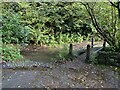
Abergavenny Ford
This ford is found on the byway below Sunny Vale near Abergavenny.
https://youtu.be/hPCW84Dzn5I
Image: © John Walton
Taken: 28 Dec 2016
0.16 miles
7
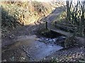
Public track to the Cibi Brook
This links the two parallel lanes, Pen-y-pound and Parc Road.
Image: © Jonathan Billinger
Taken: 10 Jun 2016
0.17 miles
8
Footpath beside the road
Brilliant!!! How often do you find a safe footpath running next to a road? How many more could councils make for safe walking in rural parts?
Image: © Graham Cole
Taken: 14 Mar 2011
0.18 miles
9
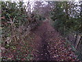
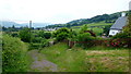
Old pathway on the Deri
One of a network of paths in this area.
Image: © Jeremy Bolwell
Taken: 27 Dec 2013
0.18 miles
10
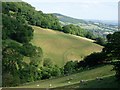
Sheep and sheep tracks
Looking across the steep valley from the car park
Image: © Hugh Venables
Taken: 11 Jul 2006
0.23 miles