IMAGES TAKEN NEAR TO
Chain Lane, ABERGAVENNY, NP7 7HH
Introduction
This page details the photographs taken nearby to Chain Lane, NP7 7HH by members of the Geograph project.
The Geograph project started in 2005 with the aim of publishing, organising and preserving representative images for every square kilometre of Great Britain, Ireland and the Isle of Man.

There are currently over 7.5m images from over14,400 individuals and you can help contribute to the project by visiting https://www.geograph.org.uk
Image Map
Images are licensed for reuse under creativecommons.org/licenses/by-sa/2.0
Notes
- Clicking on the map will re-center to the selected point.
- The higher the marker number, the further away the image location is from the centre of the postcode.
Image Listing (30 Images Found)
Images are licensed for reuse under creativecommons.org/licenses/by-sa/2.0
Image
Details
Distance
1
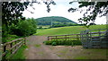
Farmland north of Chain Road
View to the wooded Twyn-yr-allt.
Image: © Jonathan Billinger
Taken: 10 Jun 2016
0.05 miles
2
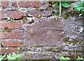
Ordnance Survey Cut Mark
This OS cut mark can be found on the SW side of Chain Road. It marks a point 100.005m above mean sea level.
Image: © Adrian Dust
Taken: 3 Jul 2020
0.07 miles
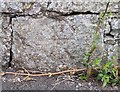
3
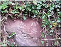
Ordnance Survey Rivet
This OS rivet can be found on the east side of the Road. It marks a point 111.631m above mean sea level.
Image: © Adrian Dust
Taken: 3 Jul 2020
0.08 miles
4
Pen-y-pound north of Chain Road and Deri Road, Abergavenny
North of crossroads http://www.geograph.org.uk/photo/2799566 Pen-y-pound is not a through road. Its northern end is about a kilometre from here, at the edge of woodland.
Image: © Jaggery
Taken: 7 Dec 2011
0.08 miles
5
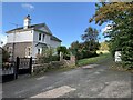
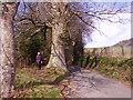
Gatehouse to Llywn Du Court
Near Abergavenny
Image: © Andrew Abbott
Taken: 30 Oct 2021
0.08 miles
6
Ordnance Survey Cut Mark
This OS cut mark can be found on the east side of the Road. It marks a point 97.118m above mean sea level.
Image: © Adrian Dust
Taken: 3 Jul 2020
0.09 miles
7
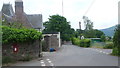
Pentre Road crossroads
Left into Chain Road, straight on for Abergavenny, right for Pentre Lane.
Image: © Jonathan Billinger
Taken: 10 Jun 2016
0.09 miles
8
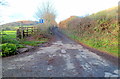
Chain Road, Abergavenny
A view west from crossroads. http://www.geograph.org.uk/photo/2799566
Image: © Jaggery
Taken: 7 Dec 2011
0.09 miles
9
Footpath off the road
Brilliant!!! A footpath alongside a narrow road giving safety and easy passage for walkers without a worry about cars.
We need more paths like this!!!
Image: © Graham Cole
Taken: 14 Mar 2011
0.10 miles
10
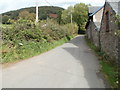
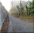
Chain Road, Abergavenny
At the northern edge of Abergavenny, Chain Road heads away from Pentre Road into the countryside.
Image: © Jaggery
Taken: 22 Oct 2010
0.11 miles