IMAGES TAKEN NEAR TO
Llwyn Du, ABERGAVENNY, NP7 7HG
Introduction
This page details the photographs taken nearby to NP7 7HG by members of the Geograph project.
The Geograph project started in 2005 with the aim of publishing, organising and preserving representative images for every square kilometre of Great Britain, Ireland and the Isle of Man.

There are currently over 7.5m images from over14,400 individuals and you can help contribute to the project by visiting https://www.geograph.org.uk
Image Map
Images are licensed for reuse under creativecommons.org/licenses/by-sa/2.0
Notes
- Clicking on the map will re-center to the selected point.
- The higher the marker number, the further away the image location is from the centre of the postcode.
Image Listing (19 Images Found)
Images are licensed for reuse under creativecommons.org/licenses/by-sa/2.0
Image
Details
Distance
3
The underground reservoir at Abergavenny
This old underground reservoir was built to supply Victorian Abergavenny and its industries, if I recall correctly. Modern Abergavenny has few industries now but was a reasonably sized railway town until the 1960's, with additional manufacturing, printing and other industries.
Image: © Jeremy Bolwell
Taken: 7 Nov 2010
0.14 miles
4
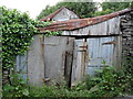
Wonderful old shed by the road up to the Sugar Loaf car park
Image: © Roger Butler
Taken: 7 Jun 2007
0.15 miles
5
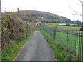
Small lane between Lwyn-du and the Deri
This tarmac lane must follow an older pathway between lush south facing pastures and the valley of the Cibi brook. The Deri hill rises behind.
Image: © Jeremy Bolwell
Taken: 7 Nov 2010
0.15 miles
6
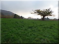
Small oak tree below the Rholben
This oak owes its stunted shape to the fact that some power lines pass over its crown and its probably been sawed or lopped down to avoid its branches causing a problem. The hill slope to the left is part of the Deri and the small conical hill in the distance to the right is the Little Skirrid or Ysgyryd Fach. These are just two of Abergavenny's five distinctive surrounding hills and two mountains.
Image: © Jeremy Bolwell
Taken: 7 Nov 2010
0.17 miles
7
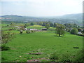
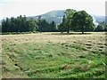
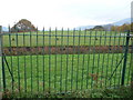
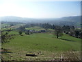
South facing fields on the lower slopes of the Rholben
Sloping sheep pasture overlooking Abergavenny.
Image: © Jeremy Bolwell
Taken: 21 May 2012
0.20 miles
8
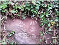
Ordnance Survey Rivet
This OS rivet can be found on the east side of the Road. It marks a point 111.631m above mean sea level.
Image: © Adrian Dust
Taken: 3 Jul 2020
0.22 miles
9
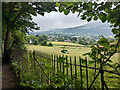
Spring sheep pastures below the Rholben, Abergavenny
Sloping south-facing sheep pastures above Llwyn-du farm.
Image: © Jeremy Bolwell
Taken: 20 Apr 2013
0.22 miles
10
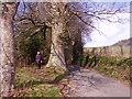
Footpath off the road
Brilliant!!! A footpath alongside a narrow road giving safety and easy passage for walkers without a worry about cars.
We need more paths like this!!!
Image: © Graham Cole
Taken: 14 Mar 2011
0.22 miles