IMAGES TAKEN NEAR TO
Llanwenarth, ABERGAVENNY, NP7 7EY
Introduction
This page details the photographs taken nearby to NP7 7EY by members of the Geograph project.
The Geograph project started in 2005 with the aim of publishing, organising and preserving representative images for every square kilometre of Great Britain, Ireland and the Isle of Man.

There are currently over 7.5m images from over14,400 individuals and you can help contribute to the project by visiting https://www.geograph.org.uk
Image Map
Images are licensed for reuse under creativecommons.org/licenses/by-sa/2.0
Notes
- Clicking on the map will re-center to the selected point.
- The higher the marker number, the further away the image location is from the centre of the postcode.
Image Listing (5 Images Found)
Images are licensed for reuse under creativecommons.org/licenses/by-sa/2.0
Image
Details
Distance
1
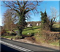
Track to houses on the north side of Brecon Road west of Abergavenny
The houses are about 100 metres north of the A40 Brecon Road.
Image: © Jaggery
Taken: 7 Feb 2014
0.08 miles

3
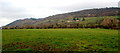
Hillside view from Llanwenarth Citra, Monmouthshire
Looking to the NNW from these https://www.geograph.org.uk/photo/6438838 field gates.
Image: © Jaggery
Taken: 29 Dec 2019
0.18 miles
4
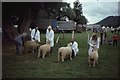
Judging, Abergavenny Show
Ryelands at the now defunct show. I have spent a lot of time trying to locate this. It is west of the town, and this field is a likely candidate. Any help would be appreciated as this is now a historic document.
Image: © Richard Webb
Taken: Unknown
0.18 miles
5
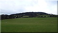
Field above the Brecon Road west of Abergavenny
This field adjacent to the Lamb and Flag pub restaurant was always a favourite sledging field during snowy conditions in my youth and I often sledged from the top hedgeline to the bottom of the field, on occasions ending up actually in the hedge such was the speed you could gain on this run.
Image: © Jeremy Bolwell
Taken: 3 Jan 2015
0.22 miles