IMAGES TAKEN NEAR TO
Orchard Street, ABERGAVENNY, NP7 7DY
Introduction
This page details the photographs taken nearby to Orchard Street, NP7 7DY by members of the Geograph project.
The Geograph project started in 2005 with the aim of publishing, organising and preserving representative images for every square kilometre of Great Britain, Ireland and the Isle of Man.

There are currently over 7.5m images from over14,400 individuals and you can help contribute to the project by visiting https://www.geograph.org.uk
Image Map
Images are licensed for reuse under creativecommons.org/licenses/by-sa/2.0
Notes
- Clicking on the map will re-center to the selected point.
- The higher the marker number, the further away the image location is from the centre of the postcode.
Image Listing (175 Images Found)
Images are licensed for reuse under creativecommons.org/licenses/by-sa/2.0
Image
Details
Distance
1
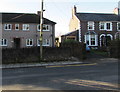
Housing variety, Chapel Road, Abergavenny
This part of Chapel Road is opposite the Harold Road junction.
Image: © Jaggery
Taken: 29 Dec 2019
0.02 miles
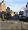
2
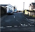
West along Orchard Street, Abergavenny
From Chapel Road along Orchard Street towards Mount Street and North Street.
Image: © Jaggery
Taken: 29 Dec 2019
0.03 miles
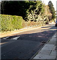
3
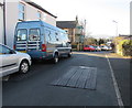
Orchard Street speed bumps, Abergavenny
A car is parked on one of two speed bumps/humps near the Mount Street junction.
Image: © Jaggery
Taken: 29 Dec 2019
0.03 miles
4
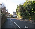
Harold Road towards Chapel Road, Abergavenny
The painted white triangle is on a speed bump/hump.
Image: © Jaggery
Taken: 29 Dec 2019
0.03 miles
5
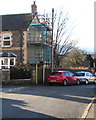
Scaffolding on a suburban corner of Abergavenny
On the side wall of the house on the corner of Mount Street and Orchard Street on December 29th 2019.
Image: © Jaggery
Taken: 29 Dec 2019
0.03 miles
6
Chapel Road speed bump, Abergavenny
Painted white triangles draw attention to the bump/hump across Chapel Road
in a 20mph speed limit zone on the approach to Cantref Primary School.
Image: © Jaggery
Taken: 29 Dec 2019
0.03 miles
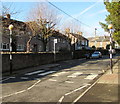
7
Orchard Street, Abergavenny
Looking east along Orchard Street from North Street.
The 30mph speed limit drops to 20mph on the approach to a school.
Image: © Jaggery
Taken: 29 Dec 2019
0.03 miles
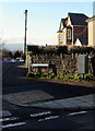
8
Zebra crossing, Chapel Road, Abergavenny
Five stripe zebra crossing near the Orchard Street junction.
Image: © Jaggery
Taken: 29 Dec 2019
0.04 miles
9
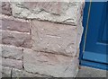
Ordnance Survey Cut Mark
This OS cut mark can be found on No32 North Street. It marks a point 62.819m above mean sea level.
Image: © Adrian Dust
Taken: 3 Jul 2020
0.04 miles
10
Royal Mail drop box on an Abergavenny corner
On the corner of Chapel Road and Orchard Street.
Image: © Jaggery
Taken: 29 Dec 2019
0.04 miles