IMAGES TAKEN NEAR TO
Linden Avenue, ABERGAVENNY, NP7 7DF
Introduction
This page details the photographs taken nearby to Linden Avenue, NP7 7DF by members of the Geograph project.
The Geograph project started in 2005 with the aim of publishing, organising and preserving representative images for every square kilometre of Great Britain, Ireland and the Isle of Man.

There are currently over 7.5m images from over14,400 individuals and you can help contribute to the project by visiting https://www.geograph.org.uk
Image Map
Images are licensed for reuse under creativecommons.org/licenses/by-sa/2.0
Notes
- Clicking on the map will re-center to the selected point.
- The higher the marker number, the further away the image location is from the centre of the postcode.
Image Listing (81 Images Found)
Images are licensed for reuse under creativecommons.org/licenses/by-sa/2.0
Image
Details
Distance
1
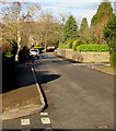
North along Chapel Road, Abergavenny
Viewed from the corner of North Street looking towards the Western Road/Linden Avenue crossroads.
Image: © Jaggery
Taken: 29 Dec 2019
0.05 miles
2
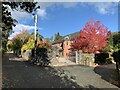
Maple in full autumn colour
On Chapel Lane, Abergavenny
Image: © Andrew Abbott
Taken: 30 Oct 2021
0.05 miles
3
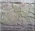
Ordnance Survey Cut Mark
This damaged OS cut mark can be found on the SW side of Chapel Road. It marks a point 75.038m above mean sea level.
Image: © Adrian Dust
Taken: 3 Jul 2020
0.05 miles
4
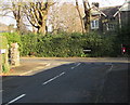
Junction of North Street and Chapel Road, Abergavenny
Looking east along North Street.
Image: © Jaggery
Taken: 29 Dec 2019
0.06 miles
5
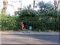
Red amid green, Chapel Road, Abergavenny
Red postbox alongside a hedge opposite North Street.
Image: © Jaggery
Taken: 29 Dec 2019
0.06 miles
6
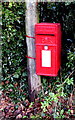
Queen Elizabeth II postbox on a Chapel Road post, Abergavenny
Located here. https://www.geograph.org.uk/photo/6355734
Image: © Jaggery
Taken: 29 Dec 2019
0.06 miles
7
Houses, hedges and cars, North Street, Abergavenny
Looking towards Chapel Road.
Image: © Jaggery
Taken: 29 Dec 2019
0.07 miles
8
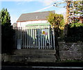
Electricity substation, North Street, Abergavenny
Steps lead up to the Western Power Distribution electricity substation in a locked enclosure above the north side of North Street. The substation identifier is CHAPEL RD ABERGAVENNY S/S 53-4726. The Chapel Road junction is nearby.
Image: © Jaggery
Taken: 29 Dec 2019
0.08 miles
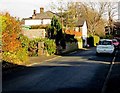
9
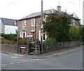
Corner of Western Road and Chapel Road, Abergavenny
A recently-sold detached house at the eastern end of Western Road, viewed across Chapel Road from the corner of Linden Avenue.
Image: © Jaggery
Taken: 22 Oct 2010
0.09 miles
10
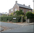
Corner of North Street and Chapel Road, Abergavenny
A detached stone-built house viewed across Chapel Road.
Image: © Jaggery
Taken: 22 Oct 2010
0.09 miles