IMAGES TAKEN NEAR TO
Avenue Crescent, ABERGAVENNY, NP7 7DE
Introduction
This page details the photographs taken nearby to Avenue Crescent, NP7 7DE by members of the Geograph project.
The Geograph project started in 2005 with the aim of publishing, organising and preserving representative images for every square kilometre of Great Britain, Ireland and the Isle of Man.

There are currently over 7.5m images from over14,400 individuals and you can help contribute to the project by visiting https://www.geograph.org.uk
Image Map
Images are licensed for reuse under creativecommons.org/licenses/by-sa/2.0
Notes
- Clicking on the map will re-center to the selected point.
- The higher the marker number, the further away the image location is from the centre of the postcode.
Image Listing (71 Images Found)
Images are licensed for reuse under creativecommons.org/licenses/by-sa/2.0
Image
Details
Distance
1
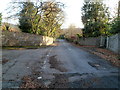
Pen-y-pound descends past an entrance to The Hill
The left turn is an entrance http://www.geograph.org.uk/photo/2799639 to a former campus of Coleg Gwent.
Image: © Jaggery
Taken: 7 Dec 2011
0.09 miles
2

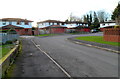
An entrance to the former Coleg Gwent The Hill campus
Viewed from Pen-y-pound. The Hill Education and Conference Centre was sold by Coleg Gwennt in 2009. A purchaser had planned to set up a ballet school here, but the plan was abandoned in 2011.
A group named CASH (Community Action to Save The Hill) has been set up with the aim of securing a sympathetic buyer for the site, especially one who would ensure its continuance as an educational site.
Image: © Jaggery
Taken: 7 Dec 2011
0.09 miles
3
Pen-y-pound Court, Abergavenny
Pen-y-pound Court is a cul-de-sac of 9 houses on the west side of a road named Pen-y-pound.
Image: © Jaggery
Taken: 7 Dec 2011
0.10 miles
4
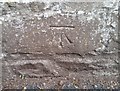
Ordnance Survey Cut Mark
This OS cut mark can be found on the west side of Hill Road. It marks a point 93.072m above mean sea level.
Image: © Adrian Dust
Taken: 3 Jul 2020
0.11 miles
5
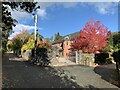
Maple in full autumn colour
On Chapel Lane, Abergavenny
Image: © Andrew Abbott
Taken: 30 Oct 2021
0.11 miles
6
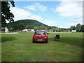
Abergavenny Cricket Club, Avenue Road
A match is in progress here and a spectator has a great vantage point looking out at a pretty idyllic setting with the Deri hill behind.
Image: © Jeremy Bolwell
Taken: 31 Aug 2013
0.12 miles
7
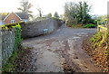
Western end of Deri Road,Abergavenny
Deri Road ends here, at crossroads. Ahead is Chain Road. The road running from left to right is Pen-y-pound.
Image: © Jaggery
Taken: 7 Dec 2011
0.16 miles
8
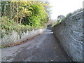
Pen-y-pound south of crossroads, Abergavenny
The road named Pen-y-pound descends into the Pen-y-pound district of Abergavenny. Viewed from crossroads. http://www.geograph.org.uk/photo/2799566
Image: © Jaggery
Taken: 7 Dec 2011
0.16 miles
9
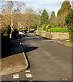
North along Chapel Road, Abergavenny
Viewed from the corner of North Street looking towards the Western Road/Linden Avenue crossroads.
Image: © Jaggery
Taken: 29 Dec 2019
0.17 miles
10
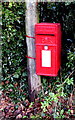
Queen Elizabeth II postbox on a Chapel Road post, Abergavenny
Located here. https://www.geograph.org.uk/photo/6355734
Image: © Jaggery
Taken: 29 Dec 2019
0.17 miles