IMAGES TAKEN NEAR TO
Avenue Road, ABERGAVENNY, NP7 7DA
Introduction
This page details the photographs taken nearby to Avenue Road, NP7 7DA by members of the Geograph project.
The Geograph project started in 2005 with the aim of publishing, organising and preserving representative images for every square kilometre of Great Britain, Ireland and the Isle of Man.

There are currently over 7.5m images from over14,400 individuals and you can help contribute to the project by visiting https://www.geograph.org.uk
Image Map
Images are licensed for reuse under creativecommons.org/licenses/by-sa/2.0
Notes
- Clicking on the map will re-center to the selected point.
- The higher the marker number, the further away the image location is from the centre of the postcode.
Image Listing (184 Images Found)
Images are licensed for reuse under creativecommons.org/licenses/by-sa/2.0
Image
Details
Distance
1
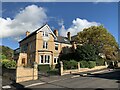
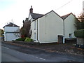
House on Avenue Road, Abergavenny
With a conservatory on the first floor.
Image: © Andrew Abbott
Taken: 30 Oct 2021
0.04 miles
2
Grade II listed The Cloisters, Abergavenny
Large house at the southern end of Pen-y-pound, now divided into 4 flats. A conveyancy document for The Cloisters in 1919 states "previously known as Derry Cottage". I have been unable to establish the year - or even the century - it was built. Grade II listed in October 2005.
Image: © Jaggery
Taken: 7 Dec 2011
0.04 miles
3
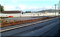
Western side of Pen-y-pound Stadium, Abergavenny
Pen-y-pound Stadium is the home ground of Abergavenny Thursdays AFC (Association Football Club). The first football club in Abergavenny, in the 1890s, was named Abergavenny Rangers. Early in the 20th century, the club was renamed Abergavenny Rangers Thursdays. The current name, Abergavenny Thursdays Football Club, was adopted in 1908.
The "Thursdays" part of their name is said to have been used because Thursday was half-day closing in Abergavenny, allowing the players (mostly apprentices, shopboys and other local workers) to be available for matches in the afternoon. But if the team was named because it was unusual to play football on Thursday (rather than the usual Saturday), against whom did they play?
Image: © Jaggery
Taken: 7 Dec 2011
0.05 miles
4
Entrance to Abergavenny Tennis Club
Located at 40, Pen-y-pound opposite Pen-y-pound Stadium. http://www.geograph.org.uk/photo/2799795
Image: © Jaggery
Taken: 7 Dec 2011
0.05 miles
5
Baptist Academy founded here in 1807, Abergavenny
A plaque http://www.geograph.org.uk/photo/2801410 on the wall of this Pen-y-pound house records that it was here that modern Baptist ministerial training began with the establishment of an academy in 1807.
Image: © Jaggery
Taken: 7 Dec 2011
0.05 miles
6
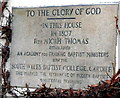
Baptist Academy 1807 plaque, Abergavenny
The plaque is on the wall of this Pen-y-pound house. http://www.geograph.org.uk/photo/2801395
It records:
TO THE GLORY OF GOD
IN THIS HOUSE IN 1807 REV MICAH THOMAS ESTABLISHED AN ACADEMY FOR TRAINING BAPTIST MINISTERS NOW THE SOUTH WALES BAPTIST COLLEGE, CARDIFF.
THIS MARKED THE BEGINNING OF MODERN BAPTIST MINISTERIAL TRAINING
Image: © Jaggery
Taken: 7 Dec 2011
0.05 miles
7
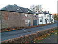
Pen-y-pound houses, Abergavenny
The houses are on the west side of Pen-y-pound, facing Pen-y-pound Stadium, http://www.geograph.org.uk/photo/2799795 the home ground of Abergavenny Thursdays Football Club.
Image: © Jaggery
Taken: 7 Dec 2011
0.05 miles
8
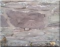
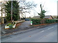
Ordnance Survey Cut Mark
This OS cut mark can be found on No28 Hill Road. It marks a point 68.562m above mean sea level.
Image: © Adrian Dust
Taken: 3 Jul 2020
0.08 miles
9
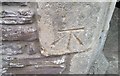
Ordnance Survey Cut Mark
This OS cut mark can be found on the gatepost of The Cloisters, Hill Road. It marks a point 66.836m above mean sea level.
Image: © Adrian Dust
Taken: 3 Jul 2020
0.08 miles
10
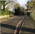
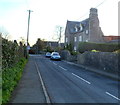
Harold Road towards Avenue Road, Abergavenny
Looking to the ENE past school railings on the right.
Image: © Jaggery
Taken: 29 Dec 2019
0.08 miles