IMAGES TAKEN NEAR TO
Meadow Lane, ABERGAVENNY, NP7 7AY
Introduction
This page details the photographs taken nearby to Meadow Lane, NP7 7AY by members of the Geograph project.
The Geograph project started in 2005 with the aim of publishing, organising and preserving representative images for every square kilometre of Great Britain, Ireland and the Isle of Man.

There are currently over 7.5m images from over14,400 individuals and you can help contribute to the project by visiting https://www.geograph.org.uk
Image Map
Images are licensed for reuse under creativecommons.org/licenses/by-sa/2.0
Notes
- Clicking on the map will re-center to the selected point.
- The higher the marker number, the further away the image location is from the centre of the postcode.
Image Listing (74 Images Found)
Images are licensed for reuse under creativecommons.org/licenses/by-sa/2.0
Image
Details
Distance
1
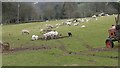
Sheep and lambs graze near Abergavenny
A seasonal scene here every year.
Image: © Jeremy Bolwell
Taken: 8 Apr 2018
0.06 miles
2
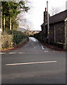
Pentre Road, Abergavenny
Viewed across the A40 Brecon Road. Ivy Cottage http://www.geograph.org.uk/photo/2501986 is on the right.
Image: © Jaggery
Taken: 7 Feb 2014
0.07 miles
3
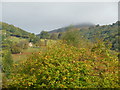
Autumn near the Sugar Loaf at Abergavenny
The changing seasons bring new colours to appreciate near the Sugar Loaf.
Image: © Jeremy Bolwell
Taken: 9 Oct 2011
0.07 miles
4
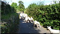
Scene on Pentre Lane, Abergavenny
A flock is being driven between pastures.
Image: © Jeremy Bolwell
Taken: 7 Sep 2014
0.08 miles
5
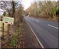
Vineyard next right, Llanwenarth
Direction sign alongside the A40 Brecon Road on the approach to the Pentre Road junction.
Image: © Jaggery
Taken: 29 Dec 2019
0.10 miles
6
A40 Brecon Road side of Ivy Cottage near Abergavenny
The letter A on the side of the cottage on the corner of Pentre Road
records that the cottage was built on the estate of the Marquis of Abergavenny.
Image: © Jaggery
Taken: 29 Dec 2019
0.10 miles
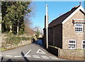
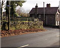
7
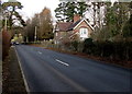
Junction of Brecon Road and Pentre Road, Llanwenarth
Looking to the NE along Pentre Road across the A40 Brecon Road.
Image: © Jaggery
Taken: 29 Dec 2019
0.10 miles
8
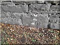
Ordnance Survey Cut Mark
This OS cut mark can be found on the wall NE side of the road. It marks a point 63.560m above mean sea level.
Image: © Adrian Dust
Taken: 23 Sep 2022
0.11 miles
9
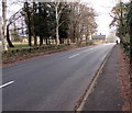
SE along the A40 Brecon Road, Llanwenarth
Ahead for Abergavenny. Behind the camera for Crickhowell and Brecon.
Image: © Jaggery
Taken: 29 Dec 2019
0.11 miles
10
Village Hall direction sign, Llanwenarth, Monmouthshire
The white arrow on the small sign on a post alongside the A40 Brecon Road points the way to the village hall. https://www.geograph.org.uk/photo/6354816
Image: © Jaggery
Taken: 29 Dec 2019
0.11 miles