IMAGES TAKEN NEAR TO
Cresta Road, ABERGAVENNY, NP7 7AU
Introduction
This page details the photographs taken nearby to Cresta Road, NP7 7AU by members of the Geograph project.
The Geograph project started in 2005 with the aim of publishing, organising and preserving representative images for every square kilometre of Great Britain, Ireland and the Isle of Man.

There are currently over 7.5m images from over14,400 individuals and you can help contribute to the project by visiting https://www.geograph.org.uk
Image Map
Images are licensed for reuse under creativecommons.org/licenses/by-sa/2.0
Notes
- Clicking on the map will re-center to the selected point.
- The higher the marker number, the further away the image location is from the centre of the postcode.
Image Listing (73 Images Found)
Images are licensed for reuse under creativecommons.org/licenses/by-sa/2.0
Image
Details
Distance
1
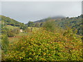
Autumn near the Sugar Loaf at Abergavenny
The changing seasons bring new colours to appreciate near the Sugar Loaf.
Image: © Jeremy Bolwell
Taken: 9 Oct 2011
0.04 miles
2
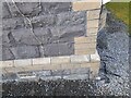
Ordnance Survey Cut Mark
This OS cut mark can be found on No9 Windsor Road. It marks a point 70.031m above mean sea level.
Image: © Adrian Dust
Taken: 23 Sep 2022
0.10 miles
3
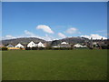
Part of Belgrave Park, Abergavenny
With a view towards the Sugar Loaf / Mynydd Pen y Fal over the roofs of Western Road and between Mynydd Llanwenarth and the Rholben.
Image: © Jeremy Bolwell
Taken: 30 Mar 2013
0.10 miles
4
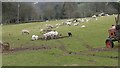
Sheep and lambs graze near Abergavenny
A seasonal scene here every year.
Image: © Jeremy Bolwell
Taken: 8 Apr 2018
0.10 miles
5

Welcome to Abergavenny - Historic market town
The sign is alongside the A40 Brecon Road at the western edge of Abergavenny.
The welcome is also in Welsh. Nearby, the National Speed Limit drops to 30mph.
Image: © Jaggery
Taken: 29 Dec 2019
0.13 miles
6

A40 Brecon Road away from Abergavenny
Looking to the northwest along the A40 towards Crickhowell and Brecon.
In the middle distance, the 30mph speed limit increases to the National Speed Limit.
Image: © Jaggery
Taken: 29 Dec 2019
0.13 miles
7
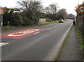
Start of the 30 zone at the western edge of Abergavenny
The National Speed Limit on the A40 Brecon Road drops to 30mph.
Image: © Jaggery
Taken: 29 Dec 2019
0.13 miles
8
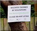
PLEASE DO NOT LITTER notice, Brecon Road, Abergavenny
On the tree on the left here https://www.geograph.org.uk/photo/6384016 in November 2019.
Image: © Jaggery
Taken: 29 Dec 2019
0.13 miles
9
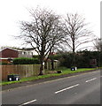
Deciduous trees and flower tubs alongside the A40 Brecon Road, Abergavenny
Viewed in November 2019. A notice https://www.geograph.org.uk/photo/6384019 on the tree on the left states
RECENTLY CLEANED BY VOLUNTEERS - PLEASE DO NOT LITTER.
Image: © Jaggery
Taken: 29 Dec 2019
0.13 miles
10
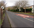
End of the 30 zone at the western edge of Abergavenny
The speed limit on the A40 Brecon Road increases to the National Speed Limit. Ahead for Crickhowell and Brecon.
Image: © Jaggery
Taken: 29 Dec 2019
0.14 miles