IMAGES TAKEN NEAR TO
Knoll Road, ABERGAVENNY, NP7 7AE
Introduction
This page details the photographs taken nearby to Knoll Road, NP7 7AE by members of the Geograph project.
The Geograph project started in 2005 with the aim of publishing, organising and preserving representative images for every square kilometre of Great Britain, Ireland and the Isle of Man.

There are currently over 7.5m images from over14,400 individuals and you can help contribute to the project by visiting https://www.geograph.org.uk
Image Map
Images are licensed for reuse under creativecommons.org/licenses/by-sa/2.0
Notes
- Clicking on the map will re-center to the selected point.
- The higher the marker number, the further away the image location is from the centre of the postcode.
Image Listing (134 Images Found)
Images are licensed for reuse under creativecommons.org/licenses/by-sa/2.0
Image
Details
Distance
1
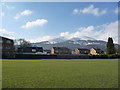
The Blorenge viewed from the western side of Abergavenny
The 'Blancmange' looks even more like a blancmange from this angle maybe. This shot was taken from Belgrave Park.
Image: © Jeremy Bolwell
Taken: 30 Mar 2013
0.02 miles
2
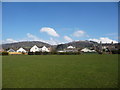
Part of Belgrave Park, Abergavenny
With a view towards the Sugar Loaf / Mynydd Pen y Fal over the roofs of Western Road and between Mynydd Llanwenarth and the Rholben.
Image: © Jeremy Bolwell
Taken: 30 Mar 2013
0.07 miles
3
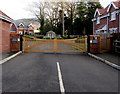
Knoll Gardens entrance gates, Abergavenny
Viewed along the access road from the A40 Brecon Road.
Image: © Jaggery
Taken: 29 Dec 2019
0.09 miles
4
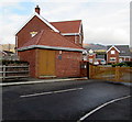
Single-storey brick building at the southern edge of Knoll Gardens, Abergavenny
The nameplate on the building shows BLUE CIRCLE HOMES.
Image: © Jaggery
Taken: 29 Dec 2019
0.09 miles
5
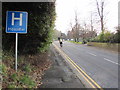
H is for Hospital, Brecon Road, Abergavenny
The sign on the right here https://www.geograph.org.uk/photo/6442087 is on the approach to Nevill Hall Hospital.
Image: © Jaggery
Taken: 29 Dec 2019
0.10 miles
6
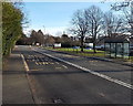
Bus stops near Nevill Hall hospital, Abergavenny
Alongside the A40 Brecon Road, on the NW side of the hospital.
Image: © Jaggery
Taken: 7 Feb 2014
0.10 miles
7
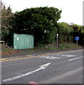
Brecon Road gas installation, Abergavenny
The Wales & West Utilities (WWU) gas installation is on the north side of the A40 Brecon Road.
On the box, an EX in a black-lined yellow triangle indicates a potentially explosive atmosphere - smoking prohibited. A notice shows a WWU phone number to ring before beginning any works on, or within 10 metres of, this site.
Image: © Jaggery
Taken: 7 Feb 2014
0.10 miles
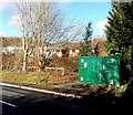
8
Large green cabinet alongside the A40 Brecon Road, Abergavenny
The cabinet is a Wales & West Utilities gas installation.
Image: © Jaggery
Taken: 29 Dec 2019
0.10 miles
9
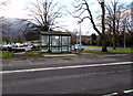
Bus stop and shelter near Nevill Hall Hospital, Abergavenny
Alongside the A40 Brecon Road viewed from the corner of Knoll Gardens.
Image: © Jaggery
Taken: 29 Dec 2019
0.11 miles
10
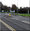
Keep Left sign in the middle of the A40 Brecon Road, Abergavenny
On the approach to Nevill Hall Hospital.
Image: © Jaggery
Taken: 29 Dec 2019
0.11 miles