IMAGES TAKEN NEAR TO
Firs Road, ABERGAVENNY, NP7 6NB
Introduction
This page details the photographs taken nearby to Firs Road, NP7 6NB by members of the Geograph project.
The Geograph project started in 2005 with the aim of publishing, organising and preserving representative images for every square kilometre of Great Britain, Ireland and the Isle of Man.

There are currently over 7.5m images from over14,400 individuals and you can help contribute to the project by visiting https://www.geograph.org.uk
Image Map
Images are licensed for reuse under creativecommons.org/licenses/by-sa/2.0
Notes
- Clicking on the map will re-center to the selected point.
- The higher the marker number, the further away the image location is from the centre of the postcode.
Image Listing (55 Images Found)
Images are licensed for reuse under creativecommons.org/licenses/by-sa/2.0
Image
Details
Distance
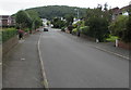
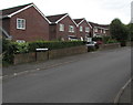
1
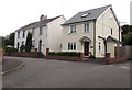
Firs Road houses, Mardy
At the northern end of Firs Road, viewed from Poplars Road.
Image: © Jaggery
Taken: 7 Aug 2017
0.01 miles
2
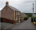
Stone houses, Poplars Road, Mardy
Numbers 1 & 2 Blorenge View and numbers 1 & 2 Osborne Place.
Image: © Jaggery
Taken: 7 Aug 2017
0.01 miles
3
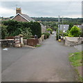
Down Poplars Road, Mardy
Poplars Road descends towards the Firs Road junction. Viewed from this gate. http://www.geograph.org.uk/photo/5489796
Image: © Jaggery
Taken: 7 Aug 2017
0.02 miles
4
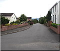
South along Firs Road, Mardy
From Poplars Road, Firs Road leads to Midway Lane and Gwent Road.
Image: © Jaggery
Taken: 7 Aug 2017
0.03 miles
5
West up Poplars Road, Mardy
Poplars Road ascends towards the right turn for Hillgrove Avenue http://www.geograph.org.uk/photo/5489656 and Llantilio Pertholey Primary School.
A school warning sign is on the right.
Image: © Jaggery
Taken: 7 Aug 2017
0.04 miles
6
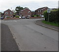
Junction of Hillgrove Avenue and Poplars Road, Mardy
Towards Poplars Road from Hillgrove Avenue.
Image: © Jaggery
Taken: 7 Aug 2017
0.04 miles
7
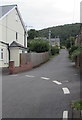
Western end of Poplars Road, Mardy
100 metres from the camera, Poplars Road ends at this http://www.geograph.org.uk/photo/5489796 gate to a public footpath.
A Firs Road house is on the left.
Image: © Jaggery
Taken: 7 Aug 2017
0.05 miles
8
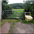
Gate at the western end of Poplars Road, Mardy
The unlocked gate gives access to a public footpath.
Image: © Jaggery
Taken: 7 Aug 2017
0.05 miles
9
South side of Poplars Road, Mardy
Viewed from the corner of Poplars Close. The bilingual (English/Welsh) sign shows 41-53 (ODDS/ODRIFAU)
Image: © Jaggery
Taken: 7 Aug 2017
0.05 miles
10

Outdated school name sign, Mardy
In August 2017 the sign on the left here http://www.geograph.org.uk/photo/5489728 shows Gwent County Council, which ceased to exist in April 1996. This area is now governed by Monmouthshire County Council.
Image: © Jaggery
Taken: 7 Aug 2017
0.06 miles