IMAGES TAKEN NEAR TO
Poplars Close, ABERGAVENNY, NP7 6LR
Introduction
This page details the photographs taken nearby to Poplars Close, NP7 6LR by members of the Geograph project.
The Geograph project started in 2005 with the aim of publishing, organising and preserving representative images for every square kilometre of Great Britain, Ireland and the Isle of Man.

There are currently over 7.5m images from over14,400 individuals and you can help contribute to the project by visiting https://www.geograph.org.uk
Image Map
Images are licensed for reuse under creativecommons.org/licenses/by-sa/2.0
Notes
- Clicking on the map will re-center to the selected point.
- The higher the marker number, the further away the image location is from the centre of the postcode.
Image Listing (59 Images Found)
Images are licensed for reuse under creativecommons.org/licenses/by-sa/2.0
Image
Details
Distance
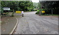
1
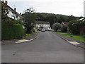
Poplars Close, Mardy
Part of a roughly rectangular area of houses north of Poplars Road.
Image: © Jaggery
Taken: 7 Aug 2017
0.01 miles
2
Northern end of Hillgrove Avenue, Mardy
The entrance road http://www.geograph.org.uk/photo/5489728 to Llantilio Pertholey Primary School is on the left.
Image: © Jaggery
Taken: 7 Aug 2017
0.02 miles
3
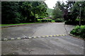
Speed bump across the entrance road to Llantilio Pertholey Primary School, Mardy
A nearby sign http://www.geograph.org.uk/photo/5489728 shows a 5 mph speed limit.
Image: © Jaggery
Taken: 7 Aug 2017
0.04 miles
4
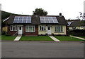
Solar panels and bungalows, Poplars Close, Mardy
Poplars Close is a roughly rectangular area of houses north of Poplars Road.
Image: © Jaggery
Taken: 7 Aug 2017
0.04 miles
5

Outdated school name sign, Mardy
In August 2017 the sign on the left here http://www.geograph.org.uk/photo/5489728 shows Gwent County Council, which ceased to exist in April 1996. This area is now governed by Monmouthshire County Council.
Image: © Jaggery
Taken: 7 Aug 2017
0.04 miles
6
Entrance to Llantilio Pertholey Primary School, Mardy
From Hillgrove Avenue. No entry except on school business. Speed limit 5 mph.
Image: © Jaggery
Taken: 7 Aug 2017
0.04 miles
7
Northern edge of Poplars Close, Mardy
Poplars Close is a roughly rectangular area of houses north of Poplars Road.
Image: © Jaggery
Taken: 7 Aug 2017
0.05 miles
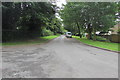
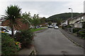
8

Hillgrove Avenue, Mardy
From Poplars Road, Hillgrove Avenue leads to the entrance to Llantilio Pertholey Primary School.
Image: © Jaggery
Taken: 7 Aug 2017
0.05 miles
9
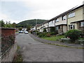
Poplars Close, Mardy
Houses in the northeast corner of Poplars Close.
Image: © Jaggery
Taken: 7 Aug 2017
0.07 miles
10
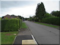
Hedge-lined Poplars Close, Mardy
Along Poplars Close towards Poplars Road.
Image: © Jaggery
Taken: 7 Aug 2017
0.07 miles