IMAGES TAKEN NEAR TO
Hereford Road, ABERGAVENNY, NP7 6HU
Introduction
This page details the photographs taken nearby to Hereford Road, NP7 6HU by members of the Geograph project.
The Geograph project started in 2005 with the aim of publishing, organising and preserving representative images for every square kilometre of Great Britain, Ireland and the Isle of Man.

There are currently over 7.5m images from over14,400 individuals and you can help contribute to the project by visiting https://www.geograph.org.uk
Image Map (Loading...)


Getting Data...Please wait
Leaflet Map data © OpenStreetMap
Images are licensed for reuse under creativecommons.org/licenses/by-sa/2.0
Notes
- Clicking on the map will re-center to the selected point.
- The higher the marker number, the further away the image location is from the centre of the postcode.
Image Listing (93 Images Found)
Images are licensed for reuse under creativecommons.org/licenses/by-sa/2.0
Image
Details
Distance
1
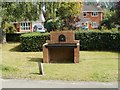
Trough, The Pines, Mardy
The trough is located on the Hereford Road side of a semicircular group of modern houses in The Pines. It appears to be an old trough with new brickwork. The black plaque shows 1897.
Image: © Jaggery
Taken: 1 Sep 2011
0.00 miles
2
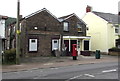
Mardy Post Office, Monmouthshire
Viewed across Hereford Road. The post office is on the corner of Gwent Road.
Below the large POST OFFICE MARDY sign on the window is 'Est(ablished) 1955'.
The two houses on the left are The Old Post Office and Warris Cottage.
Image: © Jaggery
Taken: 1 Sep 2011
0.00 miles
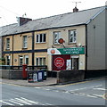
3
Mardy Stores, Mardy
Located on Hereford Road, between the Crown & Sceptre http://www.geograph.org.uk/photo/2580825 and the village post office. http://www.geograph.org.uk/photo/2580861
Image: © Jaggery
Taken: 26 Aug 2011
0.00 miles
4
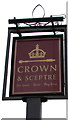
Crown & Sceptre name sign, Mardy
On the right here. http://www.geograph.org.uk/photo/5488900
Image: © Jaggery
Taken: 7 Aug 2017
0.01 miles
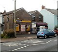
5
Former Mardy Stores, Hereford Road, Mardy
Viewed in August 2017. The former Premier covenience store seen here http://www.geograph.org.uk/photo/2580838 in 2011 has gone.
Image: © Jaggery
Taken: 7 Aug 2017
0.01 miles
7
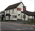
Crown & Sceptre, Mardy
Pub viewed across Hereford Road. http://www.geograph.org.uk/photo/5488907 to the name sign.
Image: © Jaggery
Taken: 7 Aug 2017
0.02 miles
8
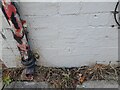
Ordnance Survey Cut Mark
This OS cut mark can be found on the former Post Office on Hereford Road. It marks a point 97.330m above mean sea level.
Image: © Adrian Dust
Taken: 23 Sep 2022
0.03 miles
9
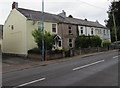
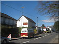
Row of houses, Hereford Road, Mardy
The house on the right is on the corner of Gwent Road.
Image: © Jaggery
Taken: 7 Aug 2017
0.03 miles
10
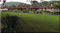
Mardy Park, Mardy
Mardy Park residential care home and day centre viewed from Hereford Road.
Image: © Jaggery
Taken: 7 Aug 2017
0.03 miles