IMAGES TAKEN NEAR TO
Wellfield Close, ABERGAVENNY, NP7 6EH
Introduction
This page details the photographs taken nearby to Wellfield Close, NP7 6EH by members of the Geograph project.
The Geograph project started in 2005 with the aim of publishing, organising and preserving representative images for every square kilometre of Great Britain, Ireland and the Isle of Man.

There are currently over 7.5m images from over14,400 individuals and you can help contribute to the project by visiting https://www.geograph.org.uk
Image Map
Images are licensed for reuse under creativecommons.org/licenses/by-sa/2.0
Notes
- Clicking on the map will re-center to the selected point.
- The higher the marker number, the further away the image location is from the centre of the postcode.
Image Listing (39 Images Found)
Images are licensed for reuse under creativecommons.org/licenses/by-sa/2.0
Image
Details
Distance
1
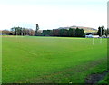
Sports ground, King Henry VIII school, Abergavenny
There are rugby pitches and football pitches on the SW side of the school buildings. Viewed from the edge of Pen-y-pound.
Image: © Jaggery
Taken: 7 Dec 2011
0.03 miles
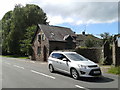
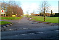
2
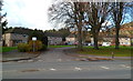
Wellfield Close, Abergavenny
Viewed from Old Hereford Road. Wellfield Close houses are arranged along three sides of a rectangle.
Image: © Jaggery
Taken: 7 Dec 2011
0.03 miles
3
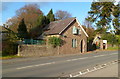
Old Cemetery Lodge, Old Hereford Road, Abergavenny
Located at the SW edge of Abergavenny Old Cemetery.
Image: © Jaggery
Taken: 7 Dec 2011
0.03 miles
4
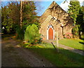
Bethany Church, Abergavenny Old Cemetery
Located inside Abergavenny Old Cemetery, near the Old Hereford Road entrance.
Image: © Jaggery
Taken: 7 Dec 2011
0.03 miles
5
Building at the entrance to the cemetery
Image: © Rob Purvis
Taken: 26 Aug 2015
0.03 miles
6
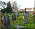
NW corner of Abergavenny Old Cemetery
The cemetery dates from 1845. The entrance is in the SW corner, from Old Hereford Road.
Image: © Jaggery
Taken: 7 Dec 2011
0.04 miles
7
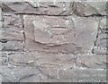
Ordnance Survey Cut Mark
This OS cut mark can be found on the Lodge NW side of the road. It marks a point 69.059m above mean sea level.
Image: © Adrian Dust
Taken: 3 Jul 2020
0.05 miles
8
Leisure centre and sports field, Abergavenny
Image: © Philip Halling
Taken: 25 Feb 2007
0.07 miles
9
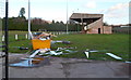
Stand, Pen-y-pound Stadium, Abergavenny
Viewed from an open gate at the edge of Pen-y-pound. The stand faces the south side of the pitch at Pen-y-pound Stadium, http://www.geograph.org.uk/photo/2799795 the home ground of Abergavenny Thursday Association Football Club.
Image: © Jaggery
Taken: 7 Dec 2011
0.11 miles
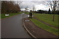
10
Western edge of King Henry VIII school, Abergavenny
Viewed from a road named Pen-y-pound. The No Entry signs show that this is an exit road for vehicles.
Image: © Jaggery
Taken: 7 Dec 2011
0.12 miles