IMAGES TAKEN NEAR TO
Ysguborwen, ABERGAVENNY, NP7 6EG
Introduction
This page details the photographs taken nearby to Ysguborwen, NP7 6EG by members of the Geograph project.
The Geograph project started in 2005 with the aim of publishing, organising and preserving representative images for every square kilometre of Great Britain, Ireland and the Isle of Man.

There are currently over 7.5m images from over14,400 individuals and you can help contribute to the project by visiting https://www.geograph.org.uk
Image Map
Images are licensed for reuse under creativecommons.org/licenses/by-sa/2.0
Notes
- Clicking on the map will re-center to the selected point.
- The higher the marker number, the further away the image location is from the centre of the postcode.
Image Listing (24 Images Found)
Images are licensed for reuse under creativecommons.org/licenses/by-sa/2.0
Image
Details
Distance
1
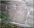
Ordnance Survey Cut Mark
This OS cut mark can be found on the Cemetery wall. It marks a point 78.961m above mean sea level.
Image: © Adrian Dust
Taken: 3 Jul 2020
0.05 miles
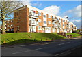
2

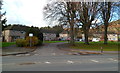
Ysguborwen, Abergavenny
View west along this residential road.
Image: © David P Howard
Taken: 2 Aug 2016
0.05 miles
3
Ysguborwen flats, Abergavenny
There are three-storey blocks of flats on the north side of the road named Ysguborwen, viewed from the Old Hereford Road end.
Image: © Jaggery
Taken: 7 Dec 2011
0.06 miles
4
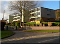
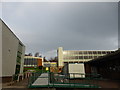
Eastern side of King Henry VIII School, Abergavenny
Viewed across Old Hereford Road.
King Henry VIII School was established in 1542. It is now a co-educational comprehensive school for 11-18 year olds. Previously located in the building now occupied by The Drama Centre, http://www.geograph.org.uk/photo/2745066 the school moved here in the 1960s. The site is shared with Abergavenny's Leisure Centre.
There are about 1,150 pupils enrolled of which 180 are in the sixth form.
Image: © Jaggery
Taken: 7 Dec 2011
0.10 miles
5
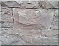
Ordnance Survey Cut Mark
This OS cut mark can be found on the Lodge NW side of the road. It marks a point 69.059m above mean sea level.
Image: © Adrian Dust
Taken: 3 Jul 2020
0.11 miles
6
Part of King Henry VIII School at Abergavenny
My old alma mater no less - originally a grammar school was established here in the 1950's I believe (the three-storey block on the right) which was extended in the early 1970's into a courtyard style flat-roofed concrete building out of shot, just in time to convert to a Comprehensive school system in the 1970's in time for my arrival. The main entrance to Upper School (home to senior pupils) lies ahead with the Assembly Hall to the left. The Abergavenny Leisure Centre is to the left also with the old gymnasium changing rooms to the right. Needless to say thousands of memories flood back into my mind as I look at this scene (from old school photos on the lawn bank to first kisses, recollection of old teachers, the music of the day and every square metre comes alive with a little tableau or scenario). The same for every ex-pupil I expect. We survived.
Image: © Jeremy Bolwell
Taken: 14 Dec 2013
0.11 miles
7
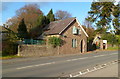
Building at the entrance to the cemetery
Image: © Rob Purvis
Taken: 26 Aug 2015
0.12 miles
8
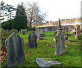
NW corner of Abergavenny Old Cemetery
The cemetery dates from 1845. The entrance is in the SW corner, from Old Hereford Road.
Image: © Jaggery
Taken: 7 Dec 2011
0.14 miles
9
Wellfield Close, Abergavenny
Viewed from Old Hereford Road. Wellfield Close houses are arranged along three sides of a rectangle.
Image: © Jaggery
Taken: 7 Dec 2011
0.15 miles
10
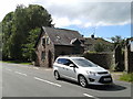
Old Cemetery Lodge, Old Hereford Road, Abergavenny
Located at the SW edge of Abergavenny Old Cemetery.
Image: © Jaggery
Taken: 7 Dec 2011
0.15 miles