IMAGES TAKEN NEAR TO
Nursery Way, ABERGAVENNY, NP7 6DJ
Introduction
This page details the photographs taken nearby to Nursery Way, NP7 6DJ by members of the Geograph project.
The Geograph project started in 2005 with the aim of publishing, organising and preserving representative images for every square kilometre of Great Britain, Ireland and the Isle of Man.

There are currently over 7.5m images from over14,400 individuals and you can help contribute to the project by visiting https://www.geograph.org.uk
Image Map
Images are licensed for reuse under creativecommons.org/licenses/by-sa/2.0
Notes
- Clicking on the map will re-center to the selected point.
- The higher the marker number, the further away the image location is from the centre of the postcode.
Image Listing (44 Images Found)
Images are licensed for reuse under creativecommons.org/licenses/by-sa/2.0
Image
Details
Distance
1

Ysguborwen, Abergavenny
View west along this residential road.
Image: © David P Howard
Taken: 2 Aug 2016
0.06 miles
2
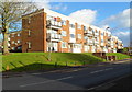
Ysguborwen flats, Abergavenny
There are three-storey blocks of flats on the north side of the road named Ysguborwen, viewed from the Old Hereford Road end.
Image: © Jaggery
Taken: 7 Dec 2011
0.12 miles
3
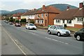
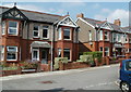
Park Avenue houses, Abergavenny
Houses on the north side of Park Avenue viewed from the Hereford Road end.
Image: © Jaggery
Taken: 1 Sep 2011
0.14 miles
4
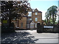
Old care home on Lansdown Road, Abergavenny
Initially built in the late Victorian era or Edwardian era as a substantial town house for the very well to do of Abergavenny on what was then, the leafy outskirts above the town.
Later surrounded by 1950's council estates the building became 'an old people's home' as they used to call them, which I assume is now no longer suitable due to changing legislation and commercial pressures, so who knows its future?
Image: © Jeremy Bolwell
Taken: 24 Jun 2012
0.14 miles
5
22 miles to Hereford from Abergavenny
The sign shows ahead for Hereford (along the unsurprisingly named Hereford Road) or turn right into Grosvenor Road (B4521) for Skenfrith, 12 miles away. The sign wrongly shows B4251, which is a road many miles away, in Caerphilly County Borough.
The corner building is a former tollhouse. http://www.geograph.org.uk/photo/1810845
Image: © Jaggery
Taken: 26 Aug 2011
0.15 miles
6
Mardy, tollhouse
Previous tollhouse at the corner of Hereford and Grosvenor Roads.
Image: © Mike Faherty
Taken: 9 Apr 2010
0.15 miles
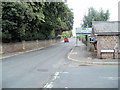
7
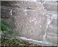
Ordnance Survey Cut Mark
This OS cut mark can be found on the Cemetery wall. It marks a point 78.961m above mean sea level.
Image: © Adrian Dust
Taken: 3 Jul 2020
0.15 miles
8
Springfield Road houses, Abergavenny
Viewed from the western end of Woodland Road.
Image: © Jaggery
Taken: 1 Sep 2011
0.15 miles
9
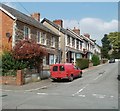
Summerfield Road Abergavenny
Houses on the west side of the road, viewed from Woodland Road.
Image: © Jaggery
Taken: 1 Sep 2011
0.15 miles
10
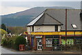
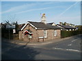
The Old General Store, Abergavenny
The Blorenge is behind it which can be seen across much of the town.
Image: © David Howard
Taken: 23 Apr 2023
0.17 miles