IMAGES TAKEN NEAR TO
Llwynu Lane, ABERGAVENNY, NP7 6AY
Introduction
This page details the photographs taken nearby to Llwynu Lane, NP7 6AY by members of the Geograph project.
The Geograph project started in 2005 with the aim of publishing, organising and preserving representative images for every square kilometre of Great Britain, Ireland and the Isle of Man.

There are currently over 7.5m images from over14,400 individuals and you can help contribute to the project by visiting https://www.geograph.org.uk
Image Map
Images are licensed for reuse under creativecommons.org/licenses/by-sa/2.0
Notes
- Clicking on the map will re-center to the selected point.
- The higher the marker number, the further away the image location is from the centre of the postcode.
Image Listing (36 Images Found)
Images are licensed for reuse under creativecommons.org/licenses/by-sa/2.0
Image
Details
Distance
1
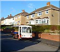
Milk float, Llwynu Lane, Abergavenny
The name on the front of the vehicle is ERNIE'S THE ROCKET.
Once a common sight in many parts of the UK, these battery-powered electric vehicles for delivering milk to houses are now a rarity. One benefit of a milk float is that is a very quiet vehicle, ideal for use in residential areas during the early hours of the morning when most people are asleep.
Image: © Jaggery
Taken: 7 Dec 2011
0.05 miles
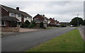
2
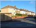
Vale View houses, Abergavenny
Houses on the north side of Vale View, viewed from Llwynu Lane.
Image: © Jaggery
Taken: 7 Dec 2011
0.08 miles
3
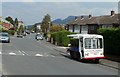
Lloyds Dairies milk float, St Teilo's Road, Mardy
Once a common sight in many parts of the UK, these battery-powered electric vehicles are now (2011) a rarity. One benefit of a milk float is that is a very quiet vehicle, ideal for use in residential areas during the early hours of the morning when most people are asleep.
Image: © Jaggery
Taken: 1 Sep 2011
0.09 miles
4
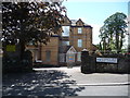
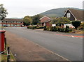
Old care home on Lansdown Road, Abergavenny
Initially built in the late Victorian era or Edwardian era as a substantial town house for the very well to do of Abergavenny on what was then, the leafy outskirts above the town.
Later surrounded by 1950's council estates the building became 'an old people's home' as they used to call them, which I assume is now no longer suitable due to changing legislation and commercial pressures, so who knows its future?
Image: © Jeremy Bolwell
Taken: 24 Jun 2012
0.12 miles
5
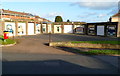
Garage artwork, Llwynu Lane, Abergavenny
The garages are on the corner of Llwynu Lane and St David's Road.
Image: © Jaggery
Taken: 7 Dec 2011
0.13 miles
6
Southern end of St Teilo's Road, Mardy
Viewed from near the corner of Hereford Road.
Image: © Jaggery
Taken: 26 Aug 2011
0.14 miles
7
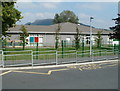
Welsh language primary school, Mardy
Ysgol Gymraeg Y Fenni is located on St David's Road in the village of Mardy, on the north side of Abergavenny. The school, for children aged 4 to 11, conducts lessons in Welsh.
Image: © Jaggery
Taken: 1 Sep 2011
0.15 miles
8
Bus shelter and phone box, St David's Road, Mardy
Dwarfed by trees, the phone box and bus shelter are at the southern edge of St David's Road, viewed from the northern edge of St Teilo's Road.
Image: © Jaggery
Taken: 1 Sep 2011
0.15 miles
9
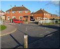
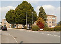
Corner of St David's Road and Llwynu Lane, Abergavenny
Viewed from near the SE edge of Deri View Primary School. http://www.geograph.org.uk/photo/2745629
Image: © Jaggery
Taken: 7 Dec 2011
0.17 miles
10
St Francis Close, Mardy
Set back from the west side of Hereford Road.
Image: © Jaggery
Taken: 7 Aug 2017
0.17 miles