IMAGES TAKEN NEAR TO
Skirrid View, Charles Close, ABERGAVENNY, NP7 6AX
Introduction
This page details the photographs taken nearby to Skirrid View, Charles Close, NP7 6AX by members of the Geograph project.
The Geograph project started in 2005 with the aim of publishing, organising and preserving representative images for every square kilometre of Great Britain, Ireland and the Isle of Man.

There are currently over 7.5m images from over14,400 individuals and you can help contribute to the project by visiting https://www.geograph.org.uk
Image Map
Images are licensed for reuse under creativecommons.org/licenses/by-sa/2.0
Notes
- Clicking on the map will re-center to the selected point.
- The higher the marker number, the further away the image location is from the centre of the postcode.
Image Listing (28 Images Found)
Images are licensed for reuse under creativecommons.org/licenses/by-sa/2.0
Image
Details
Distance
1
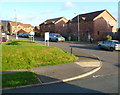
Deri View houses, Abergavenny
Viewed from Llwynu Lane.
Image: © Jaggery
Taken: 7 Dec 2011
0.05 miles
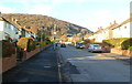
2
Charles Crescent, Abergavenny
This view from Llwynu Lane shows The Skirrid Image in the background.
Image: © Jaggery
Taken: 7 Dec 2011
0.05 miles
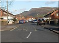
3
Charles Close, Abergavenny
Viewed from Llwynu Lane. Houses in the SW corner of Charles Close are separately named - Skirrid View. They do indeed have a view of The Skirrid (peak 486m or 1,594 ft), seen here in the background.
Image: © Jaggery
Taken: 7 Dec 2011
0.05 miles
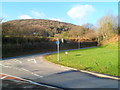
4
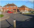
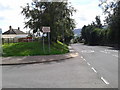
Corner of St David's Road and Llwynu Lane, Abergavenny
Viewed from near the SE edge of Deri View Primary School. http://www.geograph.org.uk/photo/2745629
Image: © Jaggery
Taken: 7 Dec 2011
0.08 miles
5
Old Hereford Road, Abergavenny
Old Hereford Road passes the Llwynu Lane junction. It's hard to believe that this road, looking like a country lane, was formerly the main route from Abergavenny to Hereford.
Image: © Jaggery
Taken: 7 Dec 2011
0.09 miles
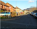
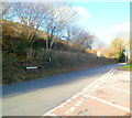
6
Looking up Llwynu Lane, Abergavenny
The distant wooded hillside is named Twyn-yr-allt.
Image: © Jaggery
Taken: 7 Dec 2011
0.09 miles
7
Northern end of Llwynu Lane, Abergavenny
Looking along Llwynu Lane towards Old Hereford Road. In the background is the wooded hill
Twyn-yr-allt, high point 343 metres (1,125 feet) above mean sea level.
Image: © Jaggery
Taken: 7 Dec 2011
0.09 miles
8
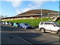
Southern side of Deri View Primary School, Abergavenny
The £7.2 million school opened in September 2005. It was built in response to the growing number of surplus primary school places in Monmouthshire. It replaced three schools: Croesonen and Llwynu Infants and St David's Junior School, which closed at the end of the summer 2005 term.
Deri View is equipped with modern facilities and technology, such as IT facilities which include laptops and interactive white boards in all classrooms. Each classroom has its own covered outdoor teaching area so lessons can be taken outside all year round. The school also has netball & basketball courts, a playing field and running track.
The school's main entrance is on the eastern side, from Llwynu Lane.
Image: © Jaggery
Taken: 7 Dec 2011
0.11 miles
10
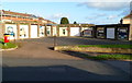
Garage artwork, Llwynu Lane, Abergavenny
The garages are on the corner of Llwynu Lane and St David's Road.
Image: © Jaggery
Taken: 7 Dec 2011
0.14 miles