IMAGES TAKEN NEAR TO
Hereford Road, ABERGAVENNY, NP7 6AA
Introduction
This page details the photographs taken nearby to Hereford Road, NP7 6AA by members of the Geograph project.
The Geograph project started in 2005 with the aim of publishing, organising and preserving representative images for every square kilometre of Great Britain, Ireland and the Isle of Man.

There are currently over 7.5m images from over14,400 individuals and you can help contribute to the project by visiting https://www.geograph.org.uk
Image Map
Images are licensed for reuse under creativecommons.org/licenses/by-sa/2.0
Notes
- Clicking on the map will re-center to the selected point.
- The higher the marker number, the further away the image location is from the centre of the postcode.
Image Listing (53 Images Found)
Images are licensed for reuse under creativecommons.org/licenses/by-sa/2.0
Image
Details
Distance
1
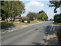
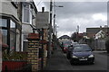
Southern boundary of Mardy, Monmouthshire
Opposite the Croesonen Road junction, Hereford Road Abergavenny becomes Hereford Road Mardy. Mardy is a small village in the north of Monmouthshire.
The street name sign on the left of the Mardy sign is for bungalows at the southern edge of St Teilo's Road, visible in the background.
Image: © Jaggery
Taken: 1 Sep 2011
0.03 miles
2
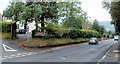
Abergavenny - gateway to Wales
Opposite the Mardy village boundary sign, http://www.geograph.org.uk/photo/2580405 a wooden sign welcomes you to Abergavenny, the gateway to Wales. Viewed across Hereford Road, at the corner of Croesonen Road.
Image: © Jaggery
Taken: 26 Aug 2011
0.03 miles
3
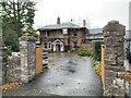
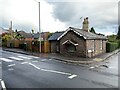
Dan-y Bryn, Hereford Road, Abergavenny
Under restoration.
Image: © Andrew Abbott
Taken: 30 Oct 2021
0.03 miles
5
Right Turn Prohibited Signage
Pre-Worboys "No Right Turn" notice in Abergavenny, on Wyndham Road.
Associated Sign in the opposing direction: Image
Image: © Luke Jones
Taken: 31 Oct 2022
0.04 miles
6
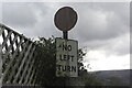
Left Turn Prohibited Signage
Pre-Worboys "No Left Turn" notice in Abergavenny, on Wyndham Road.
Associated Sign in the opposing direction: Image
Image: © Luke Jones
Taken: 31 Oct 2022
0.05 miles
7
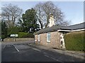
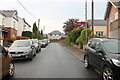
77 Hereford Road, Abergavenny
Just above the bridge which crossed the Merthyr, Tredegar and Abergavenny Railway.
Image: © Andrew Abbott
Taken: 30 Oct 2021
0.05 miles
10
22 miles to Hereford from Abergavenny
The sign shows ahead for Hereford (along the unsurprisingly named Hereford Road) or turn right into Grosvenor Road (B4521) for Skenfrith, 12 miles away. The sign wrongly shows B4251, which is a road many miles away, in Caerphilly County Borough.
The corner building is a former tollhouse. http://www.geograph.org.uk/photo/1810845
Image: © Jaggery
Taken: 26 Aug 2011
0.08 miles