IMAGES TAKEN NEAR TO
St. Helens Road, ABERGAVENNY, NP7 5YA
Introduction
This page details the photographs taken nearby to St. Helens Road, NP7 5YA by members of the Geograph project.
The Geograph project started in 2005 with the aim of publishing, organising and preserving representative images for every square kilometre of Great Britain, Ireland and the Isle of Man.

There are currently over 7.5m images from over14,400 individuals and you can help contribute to the project by visiting https://www.geograph.org.uk
Image Map
Images are licensed for reuse under creativecommons.org/licenses/by-sa/2.0
Notes
- Clicking on the map will re-center to the selected point.
- The higher the marker number, the further away the image location is from the centre of the postcode.
Image Listing (276 Images Found)
Images are licensed for reuse under creativecommons.org/licenses/by-sa/2.0
Image
Details
Distance
1
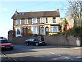
Three Sunny Bank houses, Abergavenny
The row of 3 houses is set a little above the roadway on Sunny Bank, a short street connecting Merthyr Road (behind the camera) with Park Street.
Image: © Jaggery
Taken: 7 Dec 2011
0.03 miles
3

North along St Helen's Road, Abergavenny
From Union Road East.
Image: © Jaggery
Taken: 30 Sep 2018
0.05 miles
5
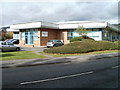
Synergy Health, Abergavenny
Located in Gavenny Court, Brecon Road.
Synergy Health Laboratory Services Ltd, a division of global healthcare provider Synergy Health plc, offers services such as occupational health screening and general pathology.
Image: © Jaggery
Taken: 22 Oct 2010
0.06 miles
6

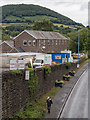
St Helen's Road, Abergavenny
View north along a row of terraced houses.
Image: © David P Howard
Taken: 2 Aug 2016
0.06 miles
7
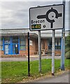
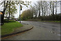
Brecon direction sign alongside the A4143, Abergavenny
Turn left at the roundabout ahead for the A40 towards Brecon.
Image: © Jaggery
Taken: 10 Sep 2023
0.06 miles
8
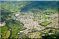
View from bridge over A4143
Looking NNE from the pedestrian foot bridge that joins the ends of Union Road East and Union Road West,
Note the Croeso (welcome) sign mowed into the hillside above, presumably specially for the Eisteddfod 2016 being held in the town.
Image: © David P Howard
Taken: 2 Aug 2016
0.07 miles
9
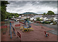
No play today
A deserted playground off Union Road East.
Image: © David P Howard
Taken: 2 Aug 2016
0.07 miles
10

Children's playground, Grofield, Abergavenny
Viewed through a Union Road East fence in the Grofield area of Abergavenny.
Image: © Jaggery
Taken: 30 Sep 2018
0.07 miles