IMAGES TAKEN NEAR TO
Union Road East, ABERGAVENNY, NP7 5UW
Introduction
This page details the photographs taken nearby to Union Road East, NP7 5UW by members of the Geograph project.
The Geograph project started in 2005 with the aim of publishing, organising and preserving representative images for every square kilometre of Great Britain, Ireland and the Isle of Man.

There are currently over 7.5m images from over14,400 individuals and you can help contribute to the project by visiting https://www.geograph.org.uk
Image Map
Images are licensed for reuse under creativecommons.org/licenses/by-sa/2.0
Notes
- Clicking on the map will re-center to the selected point.
- The higher the marker number, the further away the image location is from the centre of the postcode.
Image Listing (276 Images Found)
Images are licensed for reuse under creativecommons.org/licenses/by-sa/2.0
Image
Details
Distance
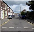
1
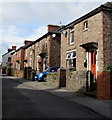
Union Road East houses, Abergavenny
Houses on the north side of Union Road East viewed from near the Merthyr Road junction.
Image: © Jaggery
Taken: 30 Sep 2018
0.01 miles
2
Park Street, Abergavenny
A view to the SSW along Park Street from the corner of Sunny Bank.
Image: © Jaggery
Taken: 7 Dec 2011
0.02 miles
3
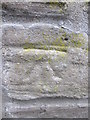
Ordnance Survey Cut Mark
This OS cut mark can be found on the wall of No67 Park Street. It marks a point 63.971m above mean sea level.
Image: © Adrian Dust
Taken: 4 Jun 2014
0.03 miles
4
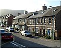
Southern end of Park Street, Abergavenny
Stone houses viewed across Union Road East.
Image: © Jaggery
Taken: 30 Sep 2018
0.03 miles
5
Park Street, Abergavenny
Viewed across Union Road East.
Image: © Jaggery
Taken: 30 Sep 2018
0.03 miles
6
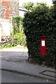
King George V postbox in an Abergavenny hedge
Alongside Union Road East. The GR on the box is short for Georgius Rex, Latin for King George, in this case King George V who reigned from May 1910-January 1936.
Image: © Jaggery
Taken: 30 Sep 2018
0.05 miles
7
Union Street East, Abergavenny
Houses on the north side of the street, viewed from the corner of Merthyr Road and Tudor Street.
Image: © Jaggery
Taken: 22 Oct 2010
0.05 miles
8

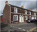
Later Victorian houses, Union Road East, Abergavenny
The small plaque on the wall between the first floor windows shows BLORENGE VIEW 1881.
Image: © Jaggery
Taken: 30 Sep 2018
0.05 miles
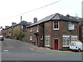
9
Westgate Cottage and Westgate House
Buildings at the junction of Merthyr Road and Union Street East. Westgate Cottage on the left was probably built around 1820 and is thought to have been a tollhouse, whilst Westgate House, the stuccoed building to which it is attached, is probably late 18th Century. Both are grade II listed - see https://cadwpublic-api.azurewebsites.net/reports/listedbuilding/FullReport?lang=&id=2439 and https://cadwpublic-api.azurewebsites.net/reports/listedbuilding/FullReport?lang=&id=86894 respectively.
Image: © Ian Capper
Taken: 9 Sep 2021
0.05 miles
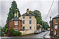
10
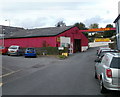
T.C.M Carpets & Beds, Abergavenny
Colourful premises located at the far end of Laundry Place, a short cul-de-sac connecting with Tudor Street.
Image: © Jaggery
Taken: 22 Oct 2010
0.05 miles