IMAGES TAKEN NEAR TO
Deri Road, ABERGAVENNY, NP7 5SY
Introduction
This page details the photographs taken nearby to Deri Road, NP7 5SY by members of the Geograph project.
The Geograph project started in 2005 with the aim of publishing, organising and preserving representative images for every square kilometre of Great Britain, Ireland and the Isle of Man.

There are currently over 7.5m images from over14,400 individuals and you can help contribute to the project by visiting https://www.geograph.org.uk
Image Map
Images are licensed for reuse under creativecommons.org/licenses/by-sa/2.0
Notes
- Clicking on the map will re-center to the selected point.
- The higher the marker number, the further away the image location is from the centre of the postcode.
Image Listing (95 Images Found)
Images are licensed for reuse under creativecommons.org/licenses/by-sa/2.0
Image
Details
Distance
1
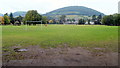
Bailey Park, Abergavenny
The roughly rectangular park measures about 375 metres x 200 metres. A blue plaque http://www.geograph.org.uk/photo/2572165 at the Hereford Road entrance records that in 1883, Crawshay Bailey II leased the land, then known as Priory Meadows. In 1894 the town purchased the park for £5000.
Image: © Jaggery
Taken: 26 Aug 2011
0.04 miles
2
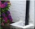
Ordnance Survey Cut Mark
This OS cut mark can be found on No139 Park Crescent. It marks a point 66.937m above mean sea level.
Image: © Adrian Dust
Taken: 3 Jul 2020
0.10 miles
3
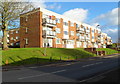
Ysguborwen flats, Abergavenny
There are three-storey blocks of flats on the north side of the road named Ysguborwen, viewed from the Old Hereford Road end.
Image: © Jaggery
Taken: 7 Dec 2011
0.10 miles
4
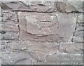
Ordnance Survey Cut Mark
This OS cut mark can be found on the Lodge NW side of the road. It marks a point 69.059m above mean sea level.
Image: © Adrian Dust
Taken: 3 Jul 2020
0.12 miles
5
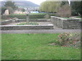
Flower beds in Bailey Park in Abergavenny
Image: © Peter Robinson
Taken: 22 Mar 2015
0.12 miles
6
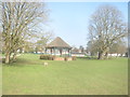
Bandstand in Bailey Park at Abergavenny
Image: © Peter Robinson
Taken: 20 Mar 2015
0.13 miles
7
View from the cattle market
Towards the wooded hill, Twyn-yr-allt, 343m.
Image: © Pauline E
Taken: 18 Jul 2009
0.13 miles
8
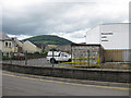
Building at the entrance to the cemetery
Image: © Rob Purvis
Taken: 26 Aug 2015
0.13 miles
9
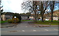
Wellfield Close, Abergavenny
Viewed from Old Hereford Road. Wellfield Close houses are arranged along three sides of a rectangle.
Image: © Jaggery
Taken: 7 Dec 2011
0.14 miles
10
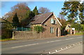
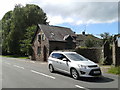
Old Cemetery Lodge, Old Hereford Road, Abergavenny
Located at the SW edge of Abergavenny Old Cemetery.
Image: © Jaggery
Taken: 7 Dec 2011
0.14 miles