IMAGES TAKEN NEAR TO
Albert Road, ABERGAVENNY, NP7 5RG
Introduction
This page details the photographs taken nearby to Albert Road, NP7 5RG by members of the Geograph project.
The Geograph project started in 2005 with the aim of publishing, organising and preserving representative images for every square kilometre of Great Britain, Ireland and the Isle of Man.

There are currently over 7.5m images from over14,400 individuals and you can help contribute to the project by visiting https://www.geograph.org.uk
Image Map
Images are licensed for reuse under creativecommons.org/licenses/by-sa/2.0
Notes
- Clicking on the map will re-center to the selected point.
- The higher the marker number, the further away the image location is from the centre of the postcode.
Image Listing (69 Images Found)
Images are licensed for reuse under creativecommons.org/licenses/by-sa/2.0
Image
Details
Distance
1
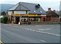
The Old General Store, Abergavenny
Despite its name, located in modern-looking premises on the corner of Hereford Road and Park Crescent. The shopkeeper told me that there had been a store here for as long as he could remember. It was extended internally, and modernised externally, 'about 3 years ago' ie in c2008.
Image: © Jaggery
Taken: 26 Aug 2011
0.05 miles
2
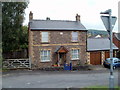
Richmond Road house, Abergavenny
Viewed from the corner of Hereford Road.
Image: © Jaggery
Taken: 26 Aug 2011
0.05 miles
3

Premier Old General Store
At the junction of Park Crescent and Hereford Road.
Image: © David P Howard
Taken: 2 Aug 2016
0.06 miles
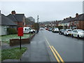
4
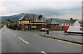
Hereford Road, Abergavenny
The Blorenge hill is on the horizon.
Image: © David Howard
Taken: 23 Apr 2023
0.06 miles
5
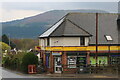
The Old General Store, Abergavenny
The Blorenge is behind it which can be seen across much of the town.
Image: © David Howard
Taken: 23 Apr 2023
0.07 miles
6
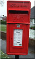
Close up, Hereford road, Abergavenny
Postbox No. NP7 26.
See Image] for wider view.
Image: © JThomas
Taken: 4 Apr 2019
0.07 miles
7
Elizabeth II postbox on Hereford road, Abergavenny
Image: © JThomas
Taken: 4 Apr 2019
0.07 miles
8
77 Hereford Road, Abergavenny
Just above the bridge which crossed the Merthyr, Tredegar and Abergavenny Railway.
Image: © Andrew Abbott
Taken: 30 Oct 2021
0.08 miles
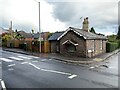
9

Ordnance Survey Cut Mark
This OS cut mark can be found on the wall at the junction of Ross Road & Albert Road. It marks a point 68.464m above mean sea level.
Image: © Adrian Dust
Taken: 3 Jul 2020
0.09 miles
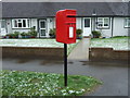
10
Park Avenue, Abergavenny
Showing position of Postbox No. NP7 26.
See Image] for postbox.
Image: © JThomas
Taken: 4 Apr 2019
0.09 miles