IMAGES TAKEN NEAR TO
Clos Y Pinwydd, ABERGAVENNY, NP7 5JP
Introduction
This page details the photographs taken nearby to Clos Y Pinwydd, NP7 5JP by members of the Geograph project.
The Geograph project started in 2005 with the aim of publishing, organising and preserving representative images for every square kilometre of Great Britain, Ireland and the Isle of Man.

There are currently over 7.5m images from over14,400 individuals and you can help contribute to the project by visiting https://www.geograph.org.uk
Image Map
Images are licensed for reuse under creativecommons.org/licenses/by-sa/2.0
Notes
- Clicking on the map will re-center to the selected point.
- The higher the marker number, the further away the image location is from the centre of the postcode.
Image Listing (155 Images Found)
Images are licensed for reuse under creativecommons.org/licenses/by-sa/2.0
Image
Details
Distance
1
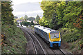
Railway near Abergavenny
Arriva Trains Wales service departs Abergavenny.
Image: © Stuart Wilding
Taken: 13 Oct 2009
0.04 miles
2
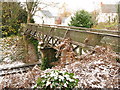
Footbridge over railway, north of Abergavenny station
Image: © Gareth James
Taken: 27 Nov 2010
0.06 miles
3
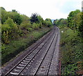
Welsh Marches railway south of the B4233, Abergavenny
Viewed from this bridge http://www.geograph.org.uk/photo/3466956 looking in the direction of Abergavenny railway station.
The sign on the right, a W in a circle, instructs the train driver to sound the locomotive's whistle or horn.
Image: © Jaggery
Taken: 17 May 2013
0.06 miles
4
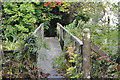
Railway Footbridge, Abergavenny
View of what can be a very slippery footbridge just north of Abergavenny Station.
Image: © Stuart Wilding
Taken: 13 Oct 2009
0.07 miles
5

The Marches Line
View from the foot crossing just north of Abergavenny Station of 66206 with the 09:30 Dee Marsh to Margam working.
Image: © Stuart Wilding
Taken: 11 Sep 2014
0.07 miles
6
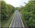
A465 SSW of the B4233, Abergavenny
The A465 here runs parallel with the Welsh Marches railway,http://www.geograph.org.uk/photo/3466981
just out of shot beyond the vegetation on the right.
Image: © Jaggery
Taken: 17 May 2013
0.08 miles
7

Holywell Close, Abergavenny
Cul-de-sac on the north side of Holywell Crescent.
Image: © Jaggery
Taken: 31 Dec 2017
0.09 miles
8
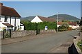
Holywell Close, Abergavenny
A cul-de-sac in a suburban area of the town, benefiting from a fine view to Deri (right, in Image), Rholben and Sugar Loaf (just visible over the roof).
Image: © Derek Harper
Taken: 28 Sep 2011
0.09 miles
9
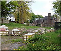
Larchfield, Abergavenny
A view from the B4233 Old Monmouth Road towards Larchfield, formerly an annexe of Pen-y-fal Hospital. Larchfield is now derelict, boarded-up and with Danger Keep Out notices on the walls.
It is surrounded by modern houses in Maes y Llarwydd. http://www.geograph.org.uk/photo/1832938
Image: © Jaggery
Taken: 17 May 2013
0.09 miles
10
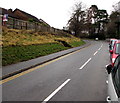
Towards a bend in the B4233, Abergavenny
Viewed from near the corner of Holywell Road. The B4233 is the road to Monmouth.
Image: © Jaggery
Taken: 31 Dec 2017
0.09 miles