IMAGES TAKEN NEAR TO
Chestnut Drive, ABERGAVENNY, NP7 5JD
Introduction
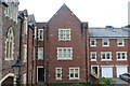
This page details the photographs taken nearby to Chestnut Drive, NP7 5JD by members of the Geograph project.
The Geograph project started in 2005 with the aim of publishing, organising and preserving representative images for every square kilometre of Great Britain, Ireland and the Isle of Man.

There are currently over 7.5m images from over14,400 individuals and you can help contribute to the project by visiting https://www.geograph.org.uk
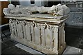
Image Map
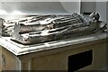
Images are licensed for reuse under creativecommons.org/licenses/by-sa/2.0
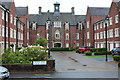
Notes
- Clicking on the map will re-center to the selected point.
- The higher the marker number, the further away the image location is from the centre of the postcode.
Image Listing (89 Images Found)
Images are licensed for reuse under creativecommons.org/licenses/by-sa/2.0
Image
Details
Distance
1
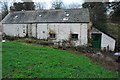
Mill House
Old Corn Mill converted into private residence, adjacent to the River Gavenny.
Records show a corn mill on this site since the 16th Century.
The mill still contains some of the old milling machinery. The mill is driven by two very rare, possibly unique tandem water wheels.
Image: © RAY JONES
Taken: 9 Jan 2007
0.04 miles
2
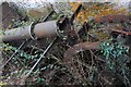
Waterwheels at Mill House
Very rare Tandem Waterwheels at Mill House. One of the five corn mills that used to be driven by the Gavenny river near Abergavenny. Both wheels operate in the same flow of water, in the same pit.
Image: © RAY JONES
Taken: 9 Jan 2007
0.05 miles
3
Bay Tree Lane, Abergavenny
Lane viewed from end of private road almost under clock tower of Sarno Square.
Image: © M J Roscoe
Taken: 19 Aug 2015
0.06 miles
4

Ordnance Survey Cut Mark
This OS cut mark can be found on the wall at the junction of Ross Road & Albert Road. It marks a point 68.464m above mean sea level.
Image: © Adrian Dust
Taken: 3 Jul 2020
0.07 miles
5
Oxford Street, Abergavenny
Viewed from the Hereford Road end. On the right is one http://www.geograph.org.uk/photo/2572276 of the many guest houses in Abergavenny.
Image: © Jaggery
Taken: 26 Aug 2011
0.07 miles
6
Abergavenny, St. Mary's Priory Church: Sir Lawrence de Hastings (d.1348) memorial
Image: © Michael Garlick
Taken: 12 Jun 2021
0.09 miles
7
Abergavenny, St. Mary's Priory Church: Sir Andrew Powell (d.1631) and wife Margaret (d.1641) memorial
Image: © Michael Garlick
Taken: 12 Jun 2021
0.09 miles
8
Rear of Sarno Square, Abergavenny
Sarno Square, formerly part of Pen-y-Fal Hospital, now converted to flats, viewed from the end of Bay Tree Lane, Image
Image: © M J Roscoe
Taken: 19 Aug 2015
0.09 miles
9
Inner bay, Sarno Square, Abergavenny
In the central bay at the rear of Sarno Square, formerly Pen-y-fal Hospital now converted to flats.
Image: © M J Roscoe
Taken: 25 May 2016
0.09 miles
10
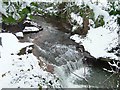
Waterfall.
A pretty waterfall is made even prettier in the snow.
Image: © G Bradshaw
Taken: 8 Feb 2007
0.09 miles