IMAGES TAKEN NEAR TO
Mill Close, ABERGAVENNY, NP7 5HJ
Introduction
This page details the photographs taken nearby to Mill Close, NP7 5HJ by members of the Geograph project.
The Geograph project started in 2005 with the aim of publishing, organising and preserving representative images for every square kilometre of Great Britain, Ireland and the Isle of Man.

There are currently over 7.5m images from over14,400 individuals and you can help contribute to the project by visiting https://www.geograph.org.uk
Image Map
Images are licensed for reuse under creativecommons.org/licenses/by-sa/2.0
Notes
- Clicking on the map will re-center to the selected point.
- The higher the marker number, the further away the image location is from the centre of the postcode.
Image Listing (503 Images Found)
Images are licensed for reuse under creativecommons.org/licenses/by-sa/2.0
Image
Details
Distance
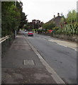
1
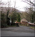
Mill Close, Abergavenny
Descending from the A40 Monmouth Road towards the River Usk.
Image: © Jaggery
Taken: 31 Dec 2017
0.02 miles
2
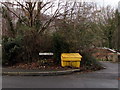
Yellow grit box, Mill Close, Abergavenny
Viewed across Monmouth Road.
Image: © Jaggery
Taken: 31 Dec 2017
0.04 miles
3
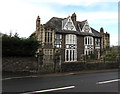
Grade II listed Ingleside and Bella Vista, Monmouth Road, Abergavenny
Distinctive semi-detached Edwardian houses built c1905. Grade II listed in 2005.
Image: © Jaggery
Taken: 31 Dec 2017
0.04 miles
4
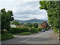
The A40 entering Abergavenny from the south
The prominent peak is Sugar Loaf (596m) in square Image
Image: © Robin Drayton
Taken: 10 Sep 2008
0.04 miles
5
South along Monmouth Road, Abergavenny
Part of the route of the A40.
Image: © Jaggery
Taken: 7 Oct 2018
0.04 miles
6

Monmouth Road houses, Abergavenny
These Monmouth Road houses are located along a quiet lane set back from the route of the A40 Monmouth Road. They border the Gavenny River. http://www.geograph.org.uk/photo/3034626
Image: © Jaggery
Taken: 1 Jul 2012
0.04 miles
7
Monmouth Road houses, Abergavenny
The back gardens of these houses are on a bank of the Gavenny River.
Image: © Jaggery
Taken: 31 Dec 2017
0.05 miles
8
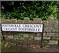
Bilingual name sign in Abergavenny
The sign on the corner of Monmouth Road shows that Fosterville Crescent is Cilgant Fosterville in Welsh.
Image: © Jaggery
Taken: 31 Dec 2017
0.05 miles
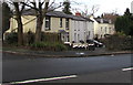
9

Large semis, Fosterville Crescent, Abergavenny
The two semi-detached houses, built in the first decade of the 20th century, each have six bedrooms.
Image: © Jaggery
Taken: 1 Jul 2012
0.05 miles
10

Large Edwardian houses, Fosterville Crescent, Abergavenny
The houses were built in the first decade of the 20th century.
Image: © Jaggery
Taken: 1 Jul 2012
0.05 miles