IMAGES TAKEN NEAR TO
Mill Street, ABERGAVENNY, NP7 5HE
Introduction
This page details the photographs taken nearby to Mill Street, NP7 5HE by members of the Geograph project.
The Geograph project started in 2005 with the aim of publishing, organising and preserving representative images for every square kilometre of Great Britain, Ireland and the Isle of Man.

There are currently over 7.5m images from over14,400 individuals and you can help contribute to the project by visiting https://www.geograph.org.uk
Image Map
Images are licensed for reuse under creativecommons.org/licenses/by-sa/2.0
Notes
- Clicking on the map will re-center to the selected point.
- The higher the marker number, the further away the image location is from the centre of the postcode.
Image Listing (679 Images Found)
Images are licensed for reuse under creativecommons.org/licenses/by-sa/2.0
Image
Details
Distance
1

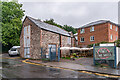
Mill Street, Abergavenny
Looking ESE along Mill Street.
Image: © David P Howard
Taken: 2 Aug 2016
0.01 miles
2
Mill Street
Road running from Cross Street to Monmouth Road. The building on the right is part of Pegasus Court.
Image: © Ian Capper
Taken: 9 Sep 2021
0.03 miles
3
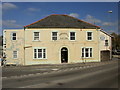
The Abergavenny Hotel, Abergavenny
Located at 21 Monmouth Road, on the southern edge of central Abergavenny.
Image: © Jaggery
Taken: 21 Apr 2010
0.04 miles
4

Mirage House, Abergavenny
Mirage House in Mill Street is the showroom of Mirage whose business includes bedrooms, bathrooms, kitchens, tiles, lighting, plumbing, heating and drainage.
Image: © Jaggery
Taken: 1 Jul 2012
0.04 miles
5

Klargester separator in the Aldi building site, Abergavenny
This is the Mill Street side of the site of a new Aldi store. http://www.geograph.org.uk/photo/3034503 The site was formerly occupied by Abergavenny Motors Garage. The separator, on the right, is used to remove pollutants such as oil, chemicals or suspended solids from surface water.
Image: © Jaggery
Taken: 1 Jul 2012
0.04 miles
6

Monmouth Road houses, Abergavenny
Viewed from Mill Street past concrete posts at the bridge across the River Gavenny. The houses are set back from the west side of the A40.
Image: © Jaggery
Taken: 1 Jul 2012
0.04 miles
7

Gavenny River downstream from Mill Street, Abergavenny
The Gavenny flows away from the footbridge connecting Mill Street with Monmouth Road houses, some of which are seen here. The Gavenny's confluence with the River Usk is about 320 metres ahead.
Image: © Jaggery
Taken: 1 Jul 2012
0.04 miles
8
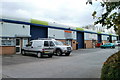
Mill Street Industrial Estate, Abergavenny
A row of units at the western end of the estate.
Mill Street Industrial Estate was constructed in the mid 1980s. There are four rows of industrial units. Each unit is similar in construction with brick elevations to about 2.1 metres (7ft) with profile steel cladding above and on the roof. There are doors for public access and dark blue steel roller shutter loading doors. The roofs are about 4.5 metres (15ft) above street level.
Image: © Jaggery
Taken: 22 Oct 2010
0.04 miles
9
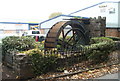
Rees's Corn Mill memorial water wheel, Abergavenny
A small water wheel, half embedded in earth, is located at the western edge of Mill Street Industrial Estate. A plaque (near the left edge of the photo) records that
THIS WATER WHEEL WAS ERECTED IN SEPTEMBER 1987 IN MEMORY OF THE PEOPLE AND TRADESMEN OF OLD MILL STREET
ON THIS SITE ONCE STOOD REES'S CORN MILL
Image: © Jaggery
Taken: 22 Oct 2010
0.04 miles
10

Western side of Mill Street Industrial Estate, Abergavenny
Mill Street Industrial Estate was constructed in the mid 1980s. In view is the smallest row of units, at the western edge of the estate. Nearest the camera in Unit 18 is 4X4 Parts, suppliers of parts for four wheel drive vehicles, especially Land Rovers.
Image: © Jaggery
Taken: 1 Jul 2012
0.04 miles