IMAGES TAKEN NEAR TO
Trinity Street, ABERGAVENNY, NP7 5EA
Introduction
This page details the photographs taken nearby to Trinity Street, NP7 5EA by members of the Geograph project.
The Geograph project started in 2005 with the aim of publishing, organising and preserving representative images for every square kilometre of Great Britain, Ireland and the Isle of Man.

There are currently over 7.5m images from over14,400 individuals and you can help contribute to the project by visiting https://www.geograph.org.uk
Image Map
Images are licensed for reuse under creativecommons.org/licenses/by-sa/2.0
Notes
- Clicking on the map will re-center to the selected point.
- The higher the marker number, the further away the image location is from the centre of the postcode.
Image Listing (603 Images Found)
Images are licensed for reuse under creativecommons.org/licenses/by-sa/2.0
Image
Details
Distance
1
Abergavenny Library
Grade II listed Carnegie library on the corner of Baker Street and Victoria Street, part of Monmouthshire Libraries and Information Service. A Carnegie library is one built with money donated by Scottish-American businessman and philanthropist Andrew Carnegie. More than 2,500 Carnegie libraries were built worldwide, including 660 in Britain and Ireland. This one dates from the first decade of the 20th century.
In August 2010, Monmouthshire County Council announced that it will replace this library with one to be built on land that will become available as part of the Abergavenny cattle market redevelopment.
Image: © Jaggery
Taken: 22 Oct 2010
0.03 miles
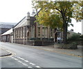
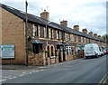
2
Baker Street houses, Abergavenny
The short row of houses is located between Tudor Street and Trinity Street.
Image: © Jaggery
Taken: 7 Dec 2011
0.04 miles
3
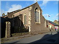
Grade II listed Church of the Holy Trinity, Abergavenny
This is the Baker Street side of the Church in Wales church, in the Diocese of Monmouth.
Holy Trinity Church was consecrated by the Bishop of Llandaff on November 6th 1840.
It was built as a chapel to serve the adjacent almshouses and the nearby school.
Grade II listed in 1974.
Image: © Jaggery
Taken: 7 Dec 2011
0.04 miles
4
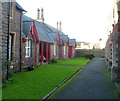
Grade II listed Trinity Almshouses, Abergavenny
This is one of two rows of almshouses inside the grounds of Holy Trinity church. http://www.geograph.org.uk/photo/2723503
This row is on the SW side of the church. The other row is parallel to it on the NE side of the church.
Grade II listed in January 1974.
Image: © Jaggery
Taken: 7 Dec 2011
0.04 miles
5
Eastern side of Grade II listed Church of the Holy Trinity, Abergavenny
A view of the church http://www.geograph.org.uk/photo/2723503 looking towards Baker Street.
Image: © Jaggery
Taken: 7 Dec 2011
0.04 miles
6
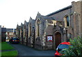
Salvation Army citadel
Salvation Army citadel in Victoria Street, built originally as a Primitive Methodist chapel. The date plaque reads 1850. Grade II listed - see https://cadwpublic-api.azurewebsites.net/reports/listedbuilding/FullReport?lang=&id=2473 (note that the listing details suggest a building year of 1830, although this is contradicted by the chapel not being marked on the 1844 tithe map).
Image: © Ian Capper
Taken: 9 Sep 2021
0.04 miles
7
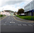
North along Baker Street, Abergavenny
From Tudor Street.
Image: © Jaggery
Taken: 30 Sep 2018
0.04 miles
8
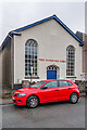
Victoria Street
1840s/50s housing in Victoria Street.
Image: © Ian Capper
Taken: 9 Sep 2021
0.05 miles
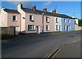
9
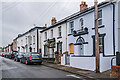
Trinity Terrace, Abergavenny
Trinity Terrace is a separately-named 95 metre long row of 18 houses in Baker Street,
opposite Holy Trinity Church. http://www.geograph.org.uk/photo/2723503
On the left is the entrance to Trinity Terrace Car Park.
Image: © Jaggery
Taken: 15 Jul 2012
0.05 miles
10
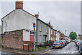
Victoria Street
1840s/50s housing in Victoria Street.
Image: © Ian Capper
Taken: 9 Sep 2021
0.05 miles